A remote island turns the Antarctic sky into a fluid-dynamics lesson
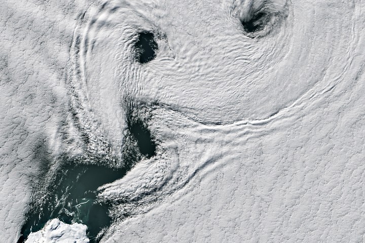
New imagery highlighted by NASA Earth Observatory shows one of the atmosphere’s most striking repeating patterns unfolding off the coast of West Antarctica: a chain of cloud swirls known as von Karman vortex streets. The display formed downwind of Peter I Island, an isolated, ice-covered volcanic island in the Bellingshausen Sea, and was captured by the Operational Land Imager on Landsat 8 on February 11, 2026.
The scene is visually dramatic, but it is also scientifically familiar. When steady air flows around an obstruction such as a mountain or island, the current can separate into alternating spinning eddies on the leeward side. In satellite imagery, those eddies can appear as a procession of comma-like cloud curls, each rotating opposite the one before it.
NASA’s description places the event in one of the windiest regions on Earth. The Southern Ocean surrounding Antarctica allows air to move with relatively little interruption from land, creating the powerful prevailing winds long nicknamed the Roaring Forties, Furious Fifties, and Screaming Sixties. Peter I Island acts as a rare obstacle in that open flow, and under the right conditions it can produce a textbook example of atmospheric wake turbulence.
Why Peter I Island matters
Peter I Island is remote even by Antarctic standards. NASA notes that it lies roughly 400 kilometers off the coast of West Antarctica and more than 1,800 kilometers from Cape Horn, Chile. The island’s isolation helps explain why observations like this are compelling: there are relatively few nearby landforms to complicate the picture, so the interaction between wind, cloud, and terrain stands out clearly.
The island itself is described as an ice-cloaked volcano. NASA says a circular crater about 100 meters wide sits at its summit, which rises 1,640 meters above sea level. The Smithsonian Institution’s Global Volcanism Program classifies it as a shield-like volcano, though NASA also notes that there are no records of recent eruptions.
That combination of elevation, shape, and exposure makes the island an efficient trigger for wave patterns and rotating eddies in the lower atmosphere. The resulting cloud structures are more than pretty satellite images. They are evidence of how air parcels lose stability, peel away from an obstacle, and reorganize into repeated vortices.
The narrow window for a clean vortex street
Not every windy day produces a clear chain of swirls. NASA says wind speeds usually need to be in a moderate range, around 18 to 54 kilometers per hour, for the vortices to form and hold their shape. If winds are too strong, the eddies break down before a neat pattern emerges.
That threshold helps explain why the February 11 image is notable. The flow was strong enough to be organized, but not so intense that the rotating structures were torn apart. The next day, NASA says, vortex streets appeared again amid a more complicated mix of cloud types, with breaks in the cloud deck revealing part of the island’s icy surface.
For atmospheric scientists and remote-sensing specialists, repeated observations matter. They can show how stable the local wind field is, how cloud height influences visibility of the pattern, and how often Peter I Island creates this kind of wake under seasonal Antarctic conditions.
What satellite images reveal beyond the spectacle
Images like this one sit at the intersection of meteorology, geography, and Earth observation. On one level, they offer a striking reminder that the atmosphere behaves like a fluid, with patterns that can often be anticipated from physical principles. On another, they demonstrate the value of long-running satellite systems such as Landsat 8, which continue to document transient events in remote places that are rarely observed from the ground.
NASA also points to an earlier airborne photograph of Peter I Island taken during an Operation IceBridge flight in 2011, underscoring how multiple observing platforms contribute to understanding the same location over time. In a region where on-site fieldwork is difficult and infrequent, each clear pass from orbit helps build a more complete record of surface and atmospheric behavior.
The image is not a sign of unusual volcanic activity, nor does NASA connect it to any immediate hazard. Its importance is simpler and still substantial: it is a high-quality view of a natural aerodynamic process unfolding over one of the least accessible parts of the planet.
That makes the scene more than an Image of the Day curiosity. It is a reminder that even in the emptiest reaches of the Southern Ocean, the interaction between wind and terrain can sketch precise, repeating structures across the sky, visible from space and explained by the same fluid mechanics that govern flow in laboratories, aircraft wakes, and ocean currents.
This article is based on reporting by science.nasa.gov. Read the original article.

Originally published on science.nasa.gov