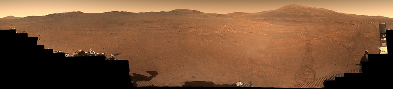
A panoramic stop at a scientifically rich boundary
NASA’s Perseverance rover has returned a 360-degree panorama from a region on the rim of Jezero Crater nicknamed “Crocodile Bridge,” offering scientists and the public a detailed look at terrain that may preserve some of the oldest accessible rocks on Mars. The mosaic, assembled from 980 images captured mostly on Dec. 18, 2025, with a small additional set collected on Jan. 25, 2026, marks more than a striking visual update. It documents the rover’s arrival at a transition zone leading into another area, “Lac de Charmes,” that NASA says Perseverance will explore for several months later this year.
Panoramas like this serve a dual role in Mars exploration. They provide broad geological context for route planning and instrument targeting, but they also help researchers interpret the layered history written into the landscape. At Jezero’s rim, that history may reach back to periods of planetary formation that Earth can no longer preserve.
Why ancient Martian rocks matter so much
NASA’s description emphasizes that the crater rim and nearby regions hold some of the oldest rocks anywhere in the solar system. That claim is scientifically important because early crustal materials can act as time capsules from an era when Mars’ crust and atmosphere were still forming. On Earth, tectonic recycling has erased or transformed most comparable surfaces. Mars, lacking active plate tectonics, preserves ancient materials that would have been consumed or heavily reworked here.
That preservation is one of the central reasons Mars remains such a compelling target for planetary science. It offers researchers a way to study early planetary environments with a clarity impossible on our own planet. Every new region Perseverance enters can therefore sharpen understanding of how rocky worlds evolve, how atmospheres change, and what environmental conditions may have existed billions of years ago.
“Crocodile Bridge” is not presented as an isolated scenic stop. It is part of a broader scientific progression through terrain selected precisely because it may reveal older chapters of Martian history than the rover has previously traversed.
The panorama is also a navigation and interpretation tool
The image set includes natural-color, enhanced-color, and anaglyph versions, allowing both realistic viewing and contrast-enhanced inspection of subtle geological features. Those different renderings matter because color and texture can reveal changes in rock composition, weathering, layering, and surface processes that are not obvious in a single presentation style.
For mission teams, a panorama of this scale helps tie together local observations with larger geomorphological patterns. A rover does not just analyze one rock at a time. It works within a carefully interpreted landscape. Broad mosaics show where outcrops connect, how slopes change, where fracture networks appear, and what route may best lead to the next high-value target.
That contextual role is especially important at a transition zone. NASA describes “Crocodile Bridge” as representing a move into the “Lac de Charmes” area, where Perseverance is expected to spend months. In practical terms, the panorama helps define the entrance to a new scientific chapter of the mission.
Jezero keeps rewarding long-duration exploration
Perseverance landed in Jezero because the crater once hosted an ancient lake and river delta, making it a promising environment in which to study past Martian habitability. As the mission has progressed, the rover’s work has increasingly expanded from the crater floor and sediment-rich settings toward older and more topographically complex terrain on the rim.
That shift matters because it broadens the mission from a search centered on ancient water environments to a more comprehensive investigation of planetary evolution. The rim region may capture processes tied to Mars’ earliest crustal history, while Jezero’s interior records later environmental conditions. Taken together, those settings can help scientists compare different eras of the planet’s development.
Long missions gain value precisely by making these transitions. A rover that survives and continues moving can connect multiple geological stories that no single stationary lander could integrate.
What comes next at Lac de Charmes
NASA says Perseverance will explore “Lac de Charmes” for several months later this year, making the “Crocodile Bridge” panorama a likely reference point for whatever comes next. The significance of that future work will depend on what the rover finds in situ, but the setup is already notable: Perseverance is moving into terrain believed to contain extremely old rocks preserved in place on a world that offers a rare archive of early solar system history.
That combination gives even a panorama strategic weight. It is not simply a beautiful record from Mars. It is a map of where the rover is poised to ask older, deeper questions about the Red Planet.
As planetary science increasingly depends on linking high-resolution imaging, mobile surface exploration, and long-term mission endurance, scenes like this show why rovers remain such powerful scientific platforms. A wide view can be more than an image. It can be the opening frame of an entirely new investigation.
This article is based on reporting by science.nasa.gov. Read the original article.
Originally published on science.nasa.gov