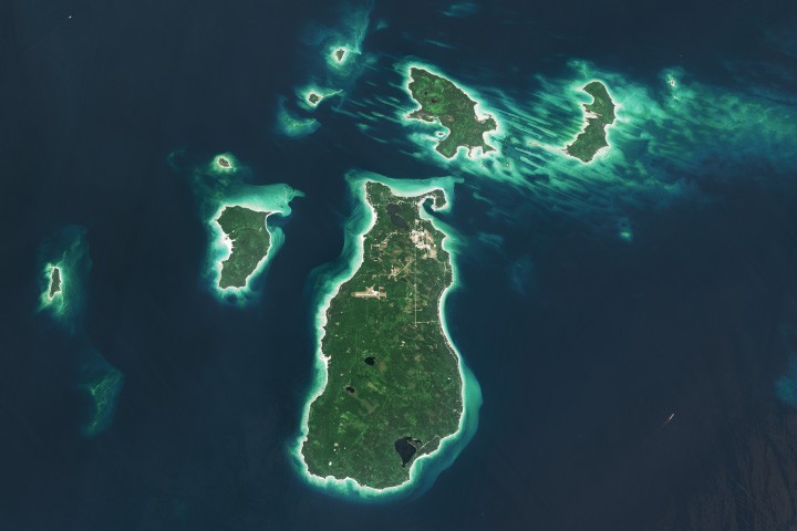
A satellite view of a Great Lakes landscape
NASA’s Earth Observatory has turned its attention to Beaver Island, the largest island in Lake Michigan, using imagery from the Operational Land Imager aboard Landsat 9 to show how geology, ecology, and human history meet in a single archipelago.
The image, captured on August 2, 2024 and featured as Earth Observatory’s Image of the Day for May 13, 2026, centers on Beaver Island and several nearby islands in the Beaver Archipelago. The view is visually striking, but its scientific value lies in what it reveals about long-term landscape formation and present-day habitat diversity.
Seen from orbit, the islands appear as green patches edged by bright sandy margins, surrounded by shallow turquoise waters and deeper blue areas where depths reach about 330 feet, or 100 meters. That color contrast is more than aesthetic. It reflects underwater topography and changing conditions across the northern Lake Michigan basin.
Shaped by ice over thousands of years
According to NASA, the islands owe their basic form to the retreat of an ancient ice sheet. As glaciers withdrew, they carved and scoured the landscape that would become the present-day Great Lakes. In northern Lake Michigan, that process left north-south ridges and valleys along the lake floor.
Some portions of those ridges were made of rock resistant enough to remain above the waterline. Those surviving high points became the Beaver Archipelago. In that sense, the islands are remnants of a much larger geological process, one in which glacial retreat did not merely remove ice but actively sculpted the terrain now visible from space.
Earth-observing satellites are especially well suited to telling that kind of story. They do not just capture scenic vistas. They allow scientists and the public to connect visible surface patterns with the deep timescales of erosion, deposition, and landscape change.

Habitats packed into a compact island system
The islands contain upland forests, dunes, wetlands, and marshes, habitats NASA says support rare plant and bird species and provide fish spawning grounds. That diversity helps explain why the archipelago matters ecologically despite its relatively modest size.
Coastal systems like this are often transitional zones where land, freshwater, and seasonal weather patterns interact in ways that create unusually rich habitats. The Earth Observatory feature does not present a new field study, but it does use remote sensing to document the spatial arrangement of those systems in a way that is immediately legible.
For the public, this kind of imagery can serve as a reminder that Earth observation is not limited to disaster tracking or climate change. It also helps maintain visibility on biodiverse places whose importance might otherwise be overlooked between major environmental events.
Beaver Island’s human story
NASA’s feature also traces the island’s social history. Beaver Island is about 13 miles long and 6 miles wide, and it is the only inhabited island in the Beaver Archipelago. Many of its roughly 600 residents are of Irish descent, giving rise to the nickname “America’s Emerald Isle.”
That identity took shape in the mid-1800s, when immigrants from County Donegal and Irish fishermen from nearby islands and Michigan ports settled there. Farming and fishing proved productive enough that, in the 1880s, Beaver Island became the largest supplier of freshwater fish in the United States. The abundance did not last, however, as overfishing eventually undercut that dominance.
The island’s history also intersected with the rise of shipping across the Great Lakes. Two lighthouses were built to guide increasing vessel traffic between Chicago and the Straits of Mackinac. The Beaver Head Lighthouse operated from 1852 to 1962 on the southern end of the island, while the Beaver Island Harbor Light on the north side, first lit in 1870, remains active.

Why this kind of feature matters
In a headline-driven news environment, an Earth Observatory feature on an island landscape can look quiet. But it plays a different role. It demonstrates how Earth science institutions use imagery to connect physical geography, ecosystems, and human settlement into a single narrative grounded in observation.
The Beaver Island image is also a case study in the continuing value of the Landsat program. By pairing long-running satellite records with editorial interpretation, NASA can turn remote sensing data into public-facing science communication that is accessible without becoming simplistic.
For readers interested in space, the story is not just about a place on Earth. It is about what orbital instruments can reveal about that place: how glaciers shaped it, how habitats organize across it, and how human communities adapted to it. Space-based observation becomes a tool for understanding local environments in finer context.
- NASA’s Earth Observatory featured Beaver Island using Landsat 9 imagery.
- The archipelago was shaped by glacial retreat that carved ridges and valleys in Lake Michigan.
- The islands contain forests, dunes, wetlands, and marshes that support diverse habitats.
- Beaver Island is the only inhabited island in the archipelago and is known as “America’s Emerald Isle.”
This article is based on reporting by science.nasa.gov. Read the original article.
Originally published on science.nasa.gov