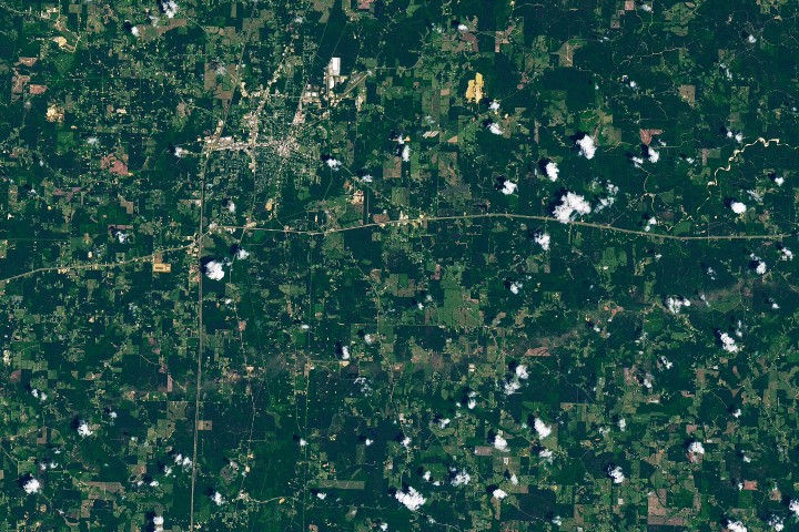
A satellite image reveals the tornado’s path
A new Earth Observatory release from NASA shows how one of Mississippi’s most powerful recent tornadoes left a visible mark on the landscape. In imagery acquired on May 12, 2026 by the Operational Land Imager aboard Landsat 8, damaged vegetation appears as a tan line across southern Mississippi. The track was created by an EF-3 tornado that tore through the region during a severe storm outbreak on May 6.
The image turns ground destruction into something legible from orbit. Trees that were snapped, uprooted, stripped of bark, or shorn of branches left behind a discolored corridor, making the tornado’s violence visible even days after the storm. NASA’s framing highlights a central strength of Earth observation: it can translate chaotic local damage into a regional picture of what happened, where the impact was concentrated, and how far it extended.
An unusually long and damaging storm track
According to the supplied NASA text, the tornado formed in St. Catherine Creek National Wildlife Refuge near the Mississippi River, roughly 60 miles west-southwest of Brookhaven. It then remained on the ground for just over two hours, traveling nearly 82 miles across five counties. That places it among some of the longest tornadoes recorded in Mississippi.
Its strongest surveyed damage reached EF-3 intensity on the Enhanced Fujita Scale, with estimated winds up to 137 miles per hour, or 220 kilometers per hour. Part of that damage appears in the Landsat scene south of Brookhaven in Lincoln County, where National Weather Service assessments documented extensive tree loss, a home with collapsed exterior walls, and a mobile home park described as devastated by debris.
The satellite view captures only one section of a much larger destruction path. The full survey cited by NASA found heavy tree damage along the tornado’s route, along with several cases of EF-2 structural damage and bent or collapsed transmission towers. That combination underscores how tornado impacts often stretch far beyond isolated building losses, affecting forests, power infrastructure, and access to essential services across a wide area.

Why the image matters beyond visual impact
The Landsat image is compelling partly because it shows how rapidly remote sensing can support situational understanding after a disaster. Tornadoes are highly localized compared with hurricanes or large wildfires, and their damage tracks can be narrow, irregular, and difficult to grasp without aerial or satellite context. By mapping vegetation changes, Earth-observing satellites can help confirm route length, identify the hardest-hit zones, and support later recovery analysis.
This does not replace the detailed work of meteorologists and emergency managers on the ground. National Weather Service post-event surveys remain essential for classifying tornado intensity, while local authorities handle rescue, shelter, and infrastructure response. But satellite imagery adds a synoptic layer that can be especially useful for public communication and historical records.
In this case, the image also shows how vegetation becomes a natural forensic record. Even when roofs are patched or debris is cleared, damaged forest cover can preserve the storm’s signature from above. That makes remote sensing valuable not only immediately after a weather event but also in tracking how landscapes recover over time.
Part of a broader severe weather outbreak
NASA notes that seven tornadoes occurred in Mississippi on the evening of May 6, according to National Weather Service preliminary data current as of May 20. The Mississippi Emergency Management Agency received reports of damage to more than 400 homes and dozens of businesses and farm buildings statewide, with the majority in Lincoln County. Those figures place the photographed tornado within a broader episode of severe weather rather than as an isolated event.
The regional context matters because southern Mississippi and the Gulf Coast are not always centered in the public imagination of U.S. tornado risk, which often focuses on the Great Plains. Yet the Southeast has long faced serious tornado hazards, including storms that can strike at night, move quickly, and intersect with forested terrain and scattered rural housing. Satellite images like this one reinforce that these risks are distributed more widely than the traditional “Tornado Alley” label implies.
For researchers and emergency planners, long-track tornadoes are especially important to study because they combine sustained atmospheric organization with the potential for large-area disruption. The longer a tornado remains on the ground, the more communities, roads, utilities, and habitats it can affect. Remote sensing helps document that footprint with consistency over time.
From orbit to recovery
The Mississippi tornado image is, on one level, an arresting picture of a brown scar across green terrain. On another, it is a reminder that Earth observation tools serve a practical role in the aftermath of extreme weather. The tan line visible in the Landsat 8 data is evidence of both immediate destruction and the value of satellite systems in recording it.
As severe weather grows more costly and communities seek faster ways to assess impact, images like this become more than public-facing illustrations. They are part of a broader monitoring network that links space-based instruments with local emergency response, meteorological surveys, and long-term recovery work. In that sense, the jagged line in Mississippi is not only a record of what the storm did. It is also a demonstration of how modern observation systems make such events easier to measure, communicate, and remember.
This article is based on reporting by science.nasa.gov. Read the original article.
Originally published on science.nasa.gov