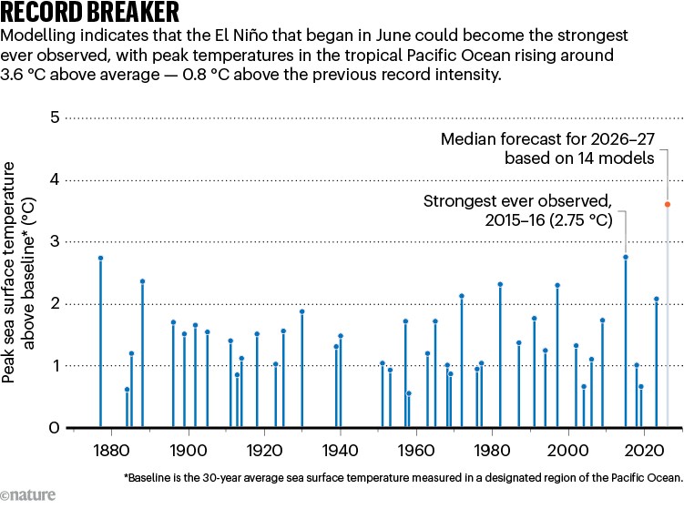
An El Niño that is still months away from its peak has already shattered a run of records — an unusual position for a climate pattern that normally saves its greatest intensity for the end of the calendar year. New Scientist reports that this event is already rewriting the record books well before its expected maximum, and that two main factors explain how it became so powerful.
That framing is worth unpacking, because it separates two different questions. The first is what an El Niño is and how it accumulates energy. The second is why this particular event has raced ahead of schedule. The answers overlap, but they are not the same thing.
A Warm Phase That Peaks Late
El Niño is the warm phase of the El Niño–Southern Oscillation, or ENSO, a coupled dance between the tropical Pacific Ocean and the atmosphere above it. In neutral conditions, trade winds blow from east to west across the equatorial Pacific, piling warm surface water up in the west near Indonesia and Australia while cold, nutrient-rich water upwells along the coast of South America.
When those winds slacken, the balance tips. Warm water spreads eastward, the zone of heaviest tropical rainfall migrates with it, and the atmosphere reorganises across the entire basin — and, through atmospheric waves, well beyond it. The pattern normally takes months to build and typically crests in the Northern Hemisphere's late autumn or early winter. The current event is still short of that peak, which is exactly what makes its early record-breaking run so notable: the strongest phase may not have arrived yet.

How an El Niño Gathers Force
The Bjerknes feedback
At the heart of every El Niño is a self-reinforcing loop named after the meteorologist Jacob Bjerknes. Weakened trade winds allow warm surface water to slide eastward. Warmer water drives stronger convection and heavier rain. That convection, in turn, reorganises the atmospheric circulation in a way that weakens the trade winds further. Each pass through the loop amplifies the anomaly.
Because this is positive feedback, something has to stop it. In practice the limits come from the ocean's finite supply of heat in the equatorial band and from the seasonal cycle, which eventually reasserts itself and begins dismantling the anomaly.
Westerly wind bursts and Kelvin waves
El Niño does not build in a smooth, steady curve. It lurches. Short-lived bursts of westerly winds over the western Pacific shove warm surface water east and generate downwelling equatorial Kelvin waves — pulses of energy that travel eastward along the thermocline, the boundary between warmer upper water and colder water below.
As those waves pass, they deepen the thermocline in the eastern Pacific. A deeper thermocline means upwelling brings up warmer water rather than cold, so the cold tongue that normally hugs the South American coast weakens. When wind bursts recur through a season, they keep topping up the event like fuel added to a fire.
Subsurface heat: the ocean's fuel tank
Surface warmth can only persist if there is heat stored beneath it. The depth of the thermocline and the volume of warm water in the upper equatorial Pacific act as a reservoir that sets a rough ceiling on how intense an event can become. Ocean-watching systems and models that track this subsurface heat generally do better at anticipating strong El Niños than those that look only at the surface.
Several ingredients tend to appear when an El Niño escalates:
- Trade winds that weaken and sometimes reverse direction
- Repeated westerly wind bursts that push the ocean further out of balance
- Equatorial Kelvin waves that deepen the thermocline and suppress cold upwelling
- A deep reservoir of subsurface heat ready to be tapped at the surface
- Intraseasonal weather, such as the Madden–Julian Oscillation, capable of triggering or sustaining those wind bursts
The Two Factors Behind an Extreme Event
New Scientist attributes this event's exceptional strength to two principal factors. Broadly, explanations for any outsized El Niño fall into two families. The first concerns the state of the ocean going in: how much heat had accumulated in the equatorial Pacific, how deep the thermocline sat, and how the trade winds had been behaving in the preceding months.
The second concerns the atmosphere's persistence. A warm ocean anomaly needs atmospheric reinforcement to grow into a monster. If wind bursts, convection and intraseasonal activity line up again and again, the ocean keeps receiving pushes in the same direction. When both families of factors are aligned — a well-stocked ocean and an atmosphere that keeps amplifying rather than damping the signal — an El Niño can outrun even generous forecasts.
It is also worth noting that strength is measured several ways. Absolute sea surface temperatures and anomalies calculated against a moving, warming baseline can rank the same event differently. That nuance matters when comparing this El Niño with historical giants, and it is one reason headlines about records should be read carefully.

What Strong Events Change
The consequences of a powerful El Niño ripple far past the tropics. Heavier rainfall typically shifts toward the eastern Pacific and the west coast of South America, raising flood risk in Peru and Ecuador, while Indonesia and parts of Australia tilt toward drought and elevated fire danger. Warm water stresses coral reefs, sometimes triggering mass bleaching.
- Shifts in tropical rainfall that reshape agricultural outlooks
- Suppressed hurricane activity in the Atlantic alongside enhanced activity in the eastern Pacific
- Coral bleaching across reefs exposed to prolonged heat
- A temporary bump in global average temperature, often most visible in the year after the peak
- Knock-on effects for fisheries, hydropower, energy demand and commodity prices
The Forecasting Problem
Forecasters watch a specific set of signals: subsurface ocean heat content, the behaviour of the trade winds, cloudiness and convection over the western Pacific, and the spread of predictions across large ensembles of climate models. Forecasts made across the middle of the year are notoriously difficult, a period often described as a predictability barrier, because the coupled system is especially sensitive to small perturbations.
Once that window closes, confidence generally improves. That means the trajectory of this event should become clearer as it approaches its seasonal peak — and because it is already setting records months early, the eventual maximum could still exceed anything observed so far. Equally, the system could plateau if the reinforcing winds fade.
The Bigger Picture
ENSO is a natural oscillation, and strong events occurred long before industrial emissions began altering the atmosphere. But every El Niño now unfolds on a warming baseline, and the ocean's background heat content has been rising over decades. A warmer, more heavily charged ocean provides more fuel for the feedbacks described above, which is one plausible reason extreme events may become more consequential even if their frequency does not change dramatically.
Attributing any single El Niño to climate change remains a research question rather than a settled answer; the honest position is that natural variability and long-term warming interact. What is not in doubt is the value of monitoring. Water managers, farmers, insurers, grid operators and disaster agencies all plan around ENSO forecasts, and the earlier a signal like this one appears, the more time they have to prepare.
For now, the story is one of a pattern running hot ahead of schedule — and of a scientific community watching closely to see whether the coming months confirm the record pace or slow it down.
This article is based on reporting by New Scientist. Read the original article.
Originally published on newscientist.com