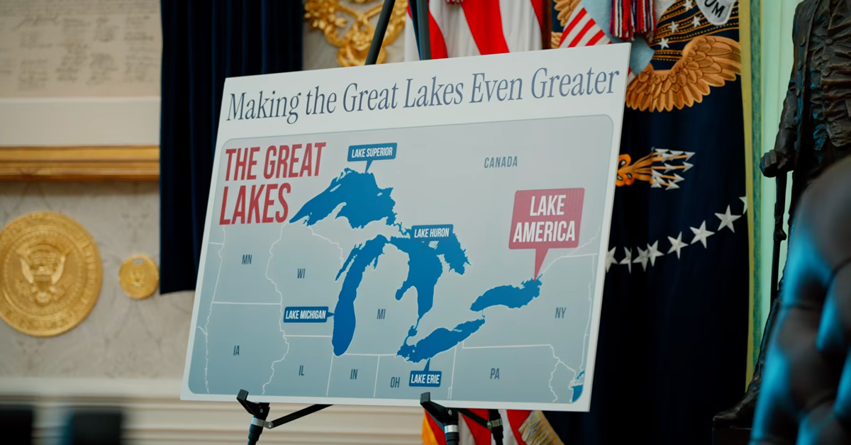
A map label change became a geopolitical flashpoint
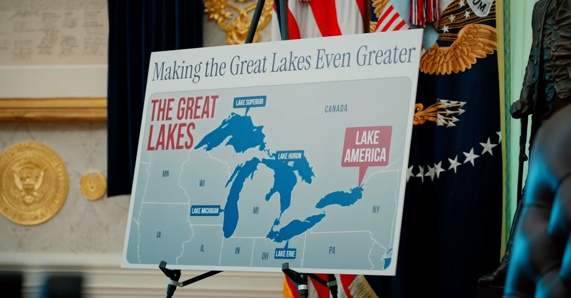
Google Maps is beginning to show Lake Ontario as “Lake America” for users in the United States after the federal government changed the name in the U.S. Geographic Names Information System, or GNIS. The move follows an executive order signed by President Donald Trump demanding the rename and has quickly turned a cartographic update into a broader dispute over politics, platform policy, and U.S.-Canada relations.
According to Google’s public explanation, the company is applying its standing practice for place-name changes that appear in official government sources. In this case, that source is GNIS for the United States. Google said users in the U.S. will see “Lake America,” users in Canada will continue to see “Lake Ontario,” and users outside both countries will see both names.
That approach makes the change more than a simple rename. It creates a geography that now varies by viewer location, with one of North America’s best-known lakes carrying different labels depending on which side of the border a user is on. The technical logic is straightforward. The political meaning is not.
Why Google changed the label
The company’s reasoning is rooted in policy consistency rather than a fresh editorial judgment about what the lake should be called. Google said it updates Maps to reflect name changes in official government sources and treats water bodies with differing cross-border names under a long-standing location-based display policy. That is essentially the same framework it used when the U.S. government renamed the Gulf of Mexico to the Gulf of America in early 2025.
For a global platform, the important point is that Google is not claiming universal authority over place names. Instead, it is deferring to a state naming database inside that state’s jurisdiction, while preserving the existing name in Canada and showing a dual label elsewhere. From a product governance perspective, that is coherent. From a public trust perspective, it is more complicated, because users often experience map interfaces as neutral descriptions of reality rather than policy-sensitive displays.
This is one reason map labeling disputes tend to generate outsized backlash. A name change on a screen can look like a factual correction, a political endorsement, or an act of digital border-making, depending on the viewer’s assumptions about what a map is supposed to do.

A local name with international consequences
Lake Ontario is not an obscure feature. The Canadian province of Ontario borders the lake on its north, west, and southwest sides, while New York borders it on the south and east. Changing the U.S. federal name therefore touches an internationally shared body of water with deep geographic, economic, and cultural significance.
The controversy is heightened by timing. The report notes that relations between the United States and Canada have deteriorated sharply, with the dispute unfolding against the backdrop of a trade conflict. Trump announced new tariffs on $20 billion worth of Canadian goods, and Canada responded with tariffs on $20 billion of U.S. goods, including steel, farm equipment, dairy products, and appliances. In that context, the lake rename reads to critics less like a quirky branding exercise and more like one more symbolic pressure point in a worsening bilateral fight.
That helps explain the intensity of the response from public officials. New York Governor Kathy Hochul condemned the rename in blunt terms, arguing that it distracts from pressing economic issues such as energy costs, prescription drugs, utility bills, and groceries. Senate Minority Leader Chuck Schumer also criticized the effort, calling the insistence on renaming the lake juvenile.
Platforms are becoming frontline institutions
The episode underlines a broader reality about digital infrastructure: platforms such as Google Maps increasingly act as frontline institutions in political disputes. A change initiated by the federal government does not become broadly visible until large consumer platforms implement it. Once they do, the platform itself becomes part of the story.
That was already evident during the Gulf of America controversy, when users reportedly review-bombed the relevant location so aggressively that Google shut down reviews. The current dispute may follow a similar pattern, especially because it concerns a body of water shared with another country and because the underlying rationale is openly geopolitical rather than descriptive.
The product design choice also illustrates how platforms manage competing sovereignties. Rather than enforcing one label worldwide, Google is segmenting the display by market and jurisdiction. That may reduce legal friction, but it also normalizes a model in which global information systems present different “official” realities to different publics.
For some observers, that is simply pragmatic compliance. For others, it is a warning that digital maps are becoming more contingent, negotiated, and politically responsive than users may realize.

Apple’s slower response adds contrast
The report notes that Apple Maps still showed “Lake Ontario” as of Sunday morning. That does not necessarily imply a permanent policy difference, but it does highlight that compliance across major platforms is neither simultaneous nor automatic. Timing matters. When one dominant map service changes a disputed label before another, the staggered rollout can sharpen the impression that the issue is unsettled even if both companies ultimately converge.
That gap also gives users a rare chance to see how dependent everyday geography has become on platform choices. The lake itself has not changed. What changed is the software layer through which millions of people encounter it.
More than a naming dispute
The “Lake America” change is easy to dismiss as spectacle, but that would miss its practical significance. Maps influence navigation, education, media language, and the public record of what places are called. When state policy, corporate rules, and international disagreement intersect in a single label, the result is a small but revealing test of who gets to define shared reality.
Google’s answer, at least for now, is procedural: follow GNIS in the U.S., preserve the established name in Canada, and show both elsewhere. That is a defensible operating rule. It is unlikely to end the argument. If anything, it clarifies how little of modern cartography is purely technical. In 2026, a map label is also a policy decision, and everyone can see it changing in real time.
This article is based on reporting by 404 Media. Read the original article.

Originally published on 404media.co