An early demonstration of a major Earth-observation mission
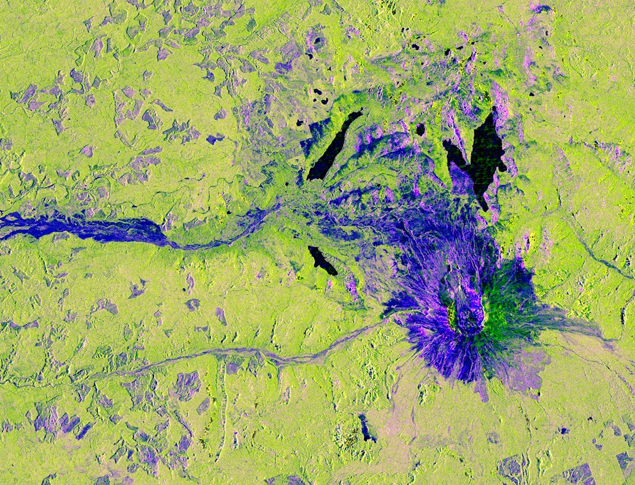
NASA has released a new NISAR image of Mount St. Helens that does more than showcase a striking volcanic landscape. It also offers one of the clearest public examples yet of what the NASA-ISRO Synthetic Aperture Radar mission is designed to do: observe Earth’s surface through cloud cover and repeatedly monitor subtle changes across land and ice.
The image, captured on Nov. 10, 2025, was published by NASA on March 27, 2026. It shows Washington’s Mount St. Helens and surrounding parts of the Pacific Northwest, cropped from a much larger swath gathered on a cloudy day. That weather detail matters because NISAR’s L-band synthetic aperture radar can see through clouds to the ground below, a core advantage over many optical Earth-imaging systems.
For a mission built around persistent monitoring rather than occasional snapshots, the image is a concise demonstration of why radar remains so important in Earth science. NISAR is not just looking for beautiful scenes. It is built to track change.
What the colors reveal
According to NASA’s description, the image’s colors are tied to how radar signals interact with surfaces on the ground. Areas that appear magenta are places where radar reflections are especially strong off flat surfaces such as roads and buildings, depending on how those surfaces are oriented relative to the satellite’s path.
Yellow can result from a range of factors, including land cover, moisture, and surface geometry. Yellow-green generally indicates vegetation, which fits the forests and wetlands surrounding Mount St. Helens. Dark blue areas correspond to relatively smooth surfaces, including water and, in this case, likely vegetation-free clearings near the mountaintop.
One of the more revealing details in the image is a set of purple square patches near the base of the volcano. Their sharp right angles make them clearly artificial, and NASA says they are likely areas where forests have been thinned or where vegetation has regrown after earlier thinning. That kind of distinction is exactly the sort of information radar imaging can surface: not just where objects are, but how land cover and surface structure differ from one area to another.
Why NISAR matters
NISAR is a joint mission between NASA and the Indian Space Research Organisation, or ISRO. It launched in July 2025 from Satish Dhawan Space Centre on India’s southeastern coast. The project is notable not only for its scientific goals but also for its structure, combining major contributions from both agencies.
NASA says the mission is the first satellite to carry two synthetic aperture radar instruments operating at different wavelengths. JPL, managed by Caltech, leads the U.S. portion of the mission and supplied the L-band SAR and the antenna reflector. ISRO provided the spacecraft bus and the S-band SAR.
That dual-radar configuration is central to the mission’s value. By operating at two wavelengths, NISAR is designed to build a richer picture of Earth’s surface conditions and changes over time. The mission will monitor land and ice surfaces twice every 12 days, creating a regular cadence of observation that can be used to detect movement, deformation, and environmental change.
A mission built for repeat measurement
Many satellites are judged by the sharpness of a single image. NISAR should be judged more by consistency and frequency. Its promise lies in revisiting the same places over and over again, gathering measurements that can be compared across time.
NASA says the spacecraft will collect data using a drum-shaped reflector measuring 39 feet, or 12 meters, across. That makes it the largest radar antenna reflector NASA has ever sent into space. The scale of that hardware is a reminder that NISAR was built for systematic global observation, not a limited or specialized campaign.
The Mount St. Helens image hints at how useful that repeat coverage could become. A volcano is a natural subject for radar monitoring because surface deformation, vegetation shifts, and terrain changes can all matter. But the mission’s mandate is much broader than volcanic terrain. Its repeated passes over land and ice are intended to provide a continuing record of how Earth’s surface is changing.
The advantage of seeing through weather
One reason the newly released image stands out is that it was taken on a cloudy day. Optical satellites are often limited by atmospheric conditions; clouds can obscure the surface and interrupt the collection of useful imagery. Radar changes that equation. By using microwaves rather than visible light, synthetic aperture radar can operate regardless of daylight and can penetrate cloud cover.
That capability does not just improve convenience. It improves continuity. For a monitoring mission, continuity is critical. If the goal is to track how landscapes, infrastructure, forests, wetlands, glaciers, or ice sheets evolve over time, gaps in observation can reduce the value of the data. Radar helps close those gaps.
The Mount St. Helens scene therefore functions as more than a promotional image. It is a proof-of-use case showing that the mission can produce interpretable, information-rich observations even when weather conditions would complicate conventional photography from orbit.
A joint mission entering public view
NISAR launched in mid-2025, but missions like this do not become broadly legible to the public until images and explanations begin to circulate. The Mount St. Helens release helps make the mission tangible. It connects an abstract set of technical specifications to a real place and a readable image.
It also highlights the practical logic behind the mission’s engineering choices: dual radar instruments, a very large reflector, and a schedule built around revisiting the same terrain. Together, those features are meant to support steady, repeatable measurement of Earth’s land and ice surfaces.
NASA’s framing is straightforward. NISAR is a monitoring mission. It is designed to collect data regularly and at scale. The image of Mount St. Helens shows that the mission is already translating that design into usable observations, with details that distinguish vegetation from clearings, smooth surfaces from built environments, and natural patterns from human-made land changes.
What this first image suggests
Early mission imagery can sometimes be little more than a visual teaser. This release feels more substantive. It demonstrates cloud-penetrating radar, showcases land-cover contrast, and underscores the value of repeated Earth observation with a system built specifically for that purpose.
For now, the Mount St. Helens image is one frame from a mission intended to generate many more. But it is an informative one. It shows NISAR doing exactly what it was launched to do: scanning broad landscapes, revealing surface structure through weather, and laying the groundwork for a sustained record of change across the planet.
This article is based on reporting by science.nasa.gov. Read the original article.
Originally published on science.nasa.gov