Satellite Images Capture a Violent Landscape Change
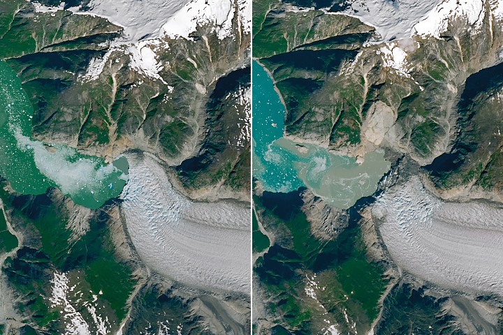
New imagery from NASA’s Earth Observatory offers a stark look at how quickly an unstable landscape can be transformed. Using Landsat 8 and Landsat 9 observations from before and after the event, NASA documented the aftermath of an August 10, 2025 landslide and tsunami in Tracy Arm, a glacial fjord in southeast Alaska. The pictures show more than a dramatic scar on a mountainside. They reveal a fjord-wide disturbance that stripped vegetation from shorelines and islands after tens of millions of cubic meters of rock crashed into the water.
The event was triggered after the rapid retreat of South Sawyer Glacier, part of a broader pattern in which shrinking ice can alter the balance of surrounding terrain. According to the supplied source text, at least 64 million cubic meters of rock slid downslope into the fjord. The impact induced a tsunami that stripped trees and other vegetation from the opposing fjord wall up to 1,578 feet, or 481 meters, above sea level. That runup height alone makes clear that this was not a localized splash or shoreline disturbance. It was a major geomorphic event.
What the Images Show
NASA compared images taken on July 26, 2025 and August 19, 2025, bracketing the disaster by just a few weeks. In the earlier view, the fjord margins appear densely vegetated. In the later image, a bright landslide scar cuts across the north side of the fjord, while a broad ring of stripped terrain marks where forest cover was leveled by the resulting wave. The contrast is unusually legible even from orbit.
The supplied text quotes geomorphologist Dan Shugar describing the result as a kind of bathtub ring around the fjord, a phrase that captures the visual clarity of the damage. One of the most telling details involves Sawyer Island, about 6 miles from the landslide source. The island shifted from green to brown in the imagery, indicating the tsunami’s destructive reach extended well beyond the immediate impact zone. Only a few trees remained standing at higher elevations.
These observations matter because fjords can concentrate wave energy in ways that make landslide-generated tsunamis especially dangerous. The surrounding walls are steep, the water is confined, and the distances between unstable slopes and vulnerable shorelines can be short. Even in remote areas, the consequences can travel quickly and violently through the landscape.
Why Glacier Retreat Changes the Hazard Map
The Tracy Arm event is not just a story about one landslide. It also illustrates how glacier retreat can change the mechanics of mountain stability. Glaciers carve valleys over long periods, and the ice itself can buttress adjacent slopes. As glaciers thin and retreat, those slopes may lose support while newly exposed terrain undergoes rapid adjustment. Fractured rock, meltwater, freeze-thaw cycles, and steep topography can combine into failure conditions that were less likely under earlier ice configurations.
The supplied source text specifically ties the Tracy Arm landslide to the rapid retreat of South Sawyer Glacier. That connection is significant because it links a visible hazard to an ongoing physical transition in cryospheric landscapes. When glaciers retreat, the hazard is not limited to sea-level implications or freshwater changes. It can also emerge as sudden terrain collapse, debris movement, and wave generation in lakes and fjords.
Researchers and hazard managers have been paying increasing attention to this class of event in high-latitude and high-mountain regions. Remote sensing is central to that effort because many of these landscapes are difficult to monitor continuously on the ground. Satellite images can reveal slope deformation, vegetation loss, shoreline alteration, and other signatures that help reconstruct what happened and identify where similar failures may occur next.
The Value of Before-and-After Earth Observation
One reason this case stands out is how clearly satellite imagery communicates the scale of the change. It is one thing to read that a landslide entered a fjord and generated a tsunami. It is another to see an entire band of forest removed from opposite slopes and nearby islands within a span of days. Earth observation turns a geological description into measurable evidence.
That is part of why NASA’s Earth Observatory images matter beyond public outreach. Before-and-after data can support scientific analysis of runup height, impacted area, sediment movement, vegetation loss, and post-event recovery. It also helps create a baseline for future risk assessment in glacial landscapes where instability may be rising as ice retreats.
Events like Tracy Arm can be easy to overlook in global climate conversations because they happen in remote locations and do not always produce immediate urban casualties. But from a hazard perspective, they are powerful reminders that climate-linked landscape change is not always gradual. Sometimes it unfolds as a threshold event: a long buildup of instability, followed by an abrupt and highly destructive release.

A Broader Warning from a Remote Fjord
Tracy Arm’s post-tsunami landscape is a case study in cascading environmental change. Glacial retreat altered local conditions. A large rock mass failed. The impact generated a tsunami. That wave stripped vegetation far above normal shorelines and across multiple locations down the fjord. In just minutes, land shaped over millennia was visibly rewritten.
The remoteness of southeast Alaska should not make the lesson feel distant. Around the world, infrastructure, tourism, shipping, research operations, and local communities intersect with mountain and glacial terrain that is changing fast. The key challenge is not simply documenting those changes after the fact, but anticipating where retreating ice may be setting the stage for new failures.
NASA’s imagery does not answer every question about future risk at Tracy Arm. It does, however, provide unusually clear evidence of how dynamic these environments can become when ice loss, steep topography, and water interact. The event shows why continued satellite monitoring matters: in rapidly changing landscapes, the next hazard may already be taking shape before anyone on the ground can see it.
This article is based on reporting by science.nasa.gov. Read the original article.
Originally published on science.nasa.gov