Satellite images and field data captured the aftermath of an extreme event
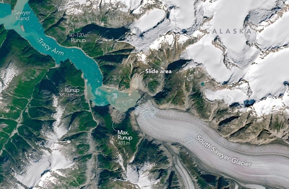
A landslide triggered by a retreating glacier in Alaska’s Tracy Arm produced one of the most extreme tsunamis ever recorded, according to research highlighted by Universe Today. Scientists reconstructed the 2025 event and found that the wave reached a maximum runup of 481 meters, or 1,578 feet, making it the second highest tsunami known to humans.
The event was not an offshore earthquake tsunami of the type most people imagine. It was a landslide-generated tsunami in a narrow fjord, where geography can concentrate energy instead of allowing it to disperse. That distinction matters, because it helps explain how an event in a relatively confined area could produce such extraordinary local effects.
The study, published in Science and led by geomorphologist Dan Shugar of the University of Calgary, used satellite imagery, aerial imagery, and ground-based data to reconstruct what happened after a large slope failure at the retreating South Sawyer Glacier in 2025.
How a glacier retreat became a tsunami hazard
As Earth warms, glaciers retreat, and that retreat does not always unfold gradually or safely. In Tracy Arm, the source report says the retreating glacier helped trigger a large landslide. When the debris slammed into the fjord, it displaced a huge volume of water and launched a wave that surged down the narrow channel toward the ocean.
The fjord itself amplified the hazard. Tracy Arm is a glacially carved corridor with steep walls that prevent water from spreading out. Instead of dissipating across a broad coast, the wave barreled through a confined space and ran high up the slopes. That produced dramatic runup zones where forests were stripped away.
One of the most vivid pieces of evidence is visible from above. Satellite and aerial images show what researchers described as a bright landslide scar on the north side of the fjord and a bathtub-like ring around the water where trees were leveled by the surge. Sawyer Island, roughly 9 kilometers down the fjord, was almost stripped bare, with only a few trees left standing.
Why landslide tsunamis can be so extreme
The source material notes that landslide-generated tsunamis can have substantially higher runups than earthquake tsunamis because they are driven by localized, violent displacement of water in settings where depth and topography vary sharply. In places like Alaskan fjords, that creates the conditions for towering waves that may not travel across entire ocean basins but can devastate everything nearby.
This is part of what makes the Alaska event so important scientifically. It adds to a growing body of evidence that cryosphere-related hazards are not confined to melting ice or sea-level rise in the abstract. Glacier retreat can destabilize slopes, and slope failure can trigger cascading events that combine geology, hydrology, and climate change.
Those cascading effects are visible in the Tracy Arm case. The initial landslide did not merely launch a single destructive wave. As the tsunami moved through the fjord, it caused additional slope failures along the way. That kind of chain reaction makes these hazards especially difficult to assess with older models that treat individual events in isolation.
A warning for vulnerable coastal corridors
The paper’s title refers to Tracy Arm as a cruise ship-frequented fjord, which adds a stark practical dimension to the science. Scenic glacier landscapes are also active hazard landscapes. A remote setting does not necessarily mean a low-consequence setting, particularly where tourism, vessels, and seasonal traffic are involved.
That does not mean every retreating glacier is on the verge of producing a megatsunami. It does mean that certain combinations of slope instability, confined waterways, and rapid environmental change deserve closer monitoring. Earth-observing satellites are central to that effort because they can reveal terrain changes, landslide scars, and stripped vegetation across areas that are difficult to monitor continuously from the ground.
The Tracy Arm reconstruction shows how powerful that surveillance can be. Researchers were able to combine imagery and field data to piece together a detailed picture of the event after the fact, but the same classes of observations may also help identify emerging risk before the next collapse occurs.
Climate change is not the whole story, but it is part of the story
It is important not to flatten a complex event into a single cause. Landslides depend on geology, slope angle, water conditions, and trigger mechanisms. But in this case, the retreat of the South Sawyer Glacier is part of the causal chain described in the source material. That makes the event more than a dramatic geologic episode. It becomes an example of how warming can change mountain and fjord systems in ways that create secondary hazards.
The 2025 Alaska megatsunami will likely be remembered for its remarkable height, but its broader significance lies in what it reveals about fragile landscapes under stress. When glaciers withdraw, they can leave behind unstable terrain and newly exposed slopes. In a steep fjord, one failure can become a wave, and one wave can reshape an entire corridor.
That is why this was not just a spectacular event caught by satellites. It was a warning embedded in the landscape. As high-latitude regions continue to warm, the scientific challenge will be to determine where similar conditions are developing next and how quickly they could turn into another extreme cascade.
This article is based on reporting by Universe Today. Read the original article.
Originally published on universetoday.com