A first-year mission result shows how dual-radar space observations can track urban land motion
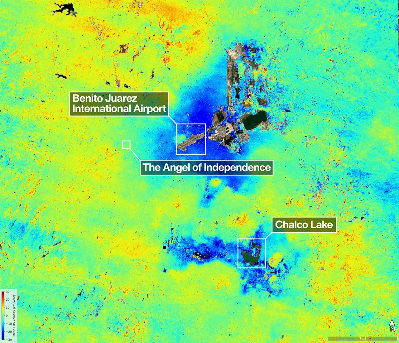
A new image from the NASA-ISRO Synthetic Aperture Radar mission, or NISAR, offers an unusually clear view of one of the world’s best-known urban geologic problems: the gradual sinking of Mexico City. Using data collected between Oct. 25, 2025, and Jan. 17, 2026, scientists produced a map showing areas of land subsidence across the metropolitan region, with some zones found to be dropping by more than half an inch, or more than 2 centimeters, per month.
On one level, the release is a vivid science image. On another, it is an operational milestone. NASA says the results help confirm that NISAR is performing as expected in its first year. That matters because the satellite, launched in 2025, is the first to carry two synthetic aperture radar instruments operating at different wavelengths. Its early performance will shape confidence in how the mission can be used for environmental monitoring, hazard assessment, and long-term Earth observation.
Why Mexico City is such an important target
Mexico City has been a hotspot of subsidence for decades, making it an ideal proving ground for a mission built to detect subtle changes at Earth’s surface. The map described by NASA highlights dark blue areas where the ground is sinking fastest. The main cause identified in the release is groundwater pumping, which has compacted the dry remains of the ancient lakebed on which much of the city was built.
That process is not just a scientific curiosity. Land subsidence can reshape drainage, worsen flood vulnerability, strain buildings and roads, and alter the performance of buried infrastructure. In a city with deep historical layers and massive population density, even small monthly changes accumulate into meaningful long-term risk. A space-based system that can repeatedly measure those shifts provides planners and researchers with a broader picture than isolated ground instruments alone can offer.
The release also notes that some yellow and red areas in the map are likely residual noise signals expected to diminish as NISAR continues collecting data and refining measurements. That caveat is important. It shows the mission is already producing useful observations while still moving through the early phase in which data quality and interpretation improve with repeated passes and calibration.
What makes NISAR technically distinct
NISAR’s design is central to why the result matters beyond Mexico. Its L-band radar instrument uses a wavelength of about 9 inches, or 24 centimeters, allowing the signal to penetrate dense vegetation such as forest canopies. Its S-band radar, provided by the Indian Space Research Organisation’s Space Applications Centre, uses a shorter microwave signal of about 4 inches, or 10 centimeters, which is more sensitive to smaller vegetation and can be effective for monitoring some agricultural and grassland systems.
Together, those instruments give the mission a broader observational toolkit than a single-band radar satellite. The dual approach means NISAR is not limited to one type of landscape or one class of problem. NASA says the mission’s data will benefit humanity by helping monitor Earth’s changing land and ice surfaces, among other applications. The Mexico City image offers an early example of that promise in practice: a dense urban setting, a measurable environmental stress, and a data product that translates a complex physical process into something legible at a glance.
The image also underscores why radar missions are so useful for change detection. Unlike ordinary optical imagery, radar can capture information about surface movement and structure in ways that are especially powerful for repeated comparisons over time. That makes it well suited to tracking deformation, whether from groundwater extraction, landslides, earthquakes, ice motion, or infrastructure instability.
A map that connects science, history, and ecology
NASA’s description of the image places the subsidence in a wider landscape context. Visible in the scene is Nabor Carrillo, an artificial lake northeast of the airport constructed over the former Lake Texcoco. To the south lies the Chalco Lake wetland, tied to a historically fertile region and named for a much larger body of water that was drained over centuries in an effort to reduce flooding in the city.
Those geographic references matter because subsidence in Mexico City is inseparable from the area’s hydrologic history. The city’s relationship to water has always involved large engineering interventions, altered ecosystems, and tradeoffs between urban expansion and environmental stability. The release even points to the Mexican axolotl, the endangered salamander famous for its regenerative ability, whose natural habitat was linked to the ancient lake system. That connection gives the NISAR image a broader resonance: it is not simply a technical measurement but a snapshot of how modern urban stress overlays a transformed ecological past.
The map also identifies the Angel of Independence, the landmark monument built in 1910 to commemorate 100 years of Mexico’s independence. NASA notes that 14 steps have been added to its base over time as the surrounding land gradually sank. It is a striking example of slow geologic change becoming visible in everyday civic architecture.
Why this early result matters
Space missions often prove their value through cumulative datasets, but first-year examples still matter. They help show whether an instrument is doing the work it was built to do, and they provide a public demonstration of why expensive Earth-observing systems are worth maintaining. In this case, NISAR has produced a result that is both technically meaningful and instantly understandable: a map of a living city moving downward in measurable increments.
If later observations reduce noise and preserve the same overall pattern, the mission could become an important source for repeated monitoring of urban deformation and environmental change. For now, the Mexico City product stands as an early validation of NISAR’s capabilities and a reminder that some of the most consequential space data are not about distant planets, but about the shifting ground beneath major population centers on Earth.
This article is based on reporting by science.nasa.gov. Read the original article.
Originally published on science.nasa.gov