An ancient process caught in a modern image
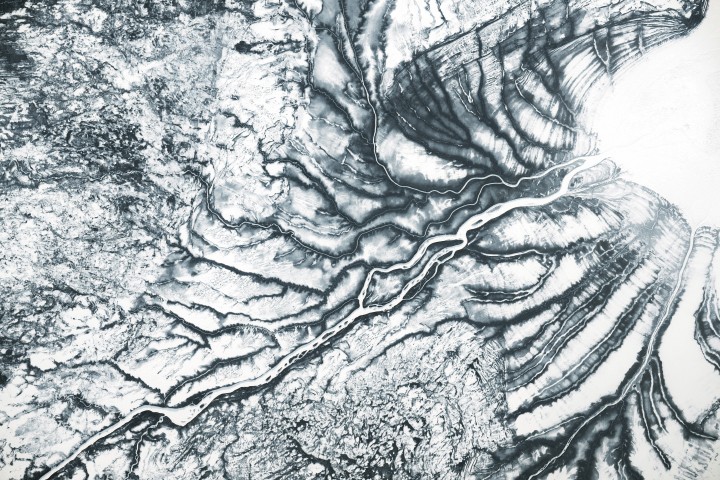
A new NASA Earth Observatory image of the James Bay Lowlands offers a striking reminder that some of Earth’s largest geological changes unfold in plain sight and on human timescales. The photo, captured in late March 2026 by an astronaut aboard the International Space Station, shows frozen channels feeding Hannah Bay in northern Canada. At first glance the scene appears muted and still, but the landscape carries the imprint of a powerful and ongoing transformation: land rising after the retreat of a continental ice sheet.
The region sits near Hudson Bay, where the Laurentide Ice Sheet once reached immense thickness during the Pleistocene. That ice mass was so heavy that it depressed the crust beneath it. Since the ice retreated after the Last Glacial Maximum around 20,000 years ago, the land has been rebounding upward. NASA says the rate around southern Hudson Bay remains relatively rapid, with the surface still rising by about 10 millimeters per year, or roughly 1 meter per century.
Why the ridges matter
The value of the image lies in what it makes visible. Snow and sea ice accentuate subtle topography that is easy to miss during greener months. Along the shore of ice-covered James Bay, faint ridges run parallel to the coast near the mouth of the Harricana River. These are beach ridges formed as tidal action reworked sands and silts along former shorelines. As the land continues to rise and relative sea level drops, newer ridges form closer to the water.
That pattern turns the coast into a kind of geological archive. Each ridge marks an earlier shoreline, preserving the combined record of glacial retreat, crustal rebound, and coastal processes. Seen from orbit, the result is a layered landscape where past sea levels and present uplift coexist in one frame. It is a concise illustration of glacial isostatic adjustment, a concept often taught abstractly but rarely observed so clearly in a single image.
The photograph also shows how winter conditions can reveal structure rather than conceal it. In early spring, the boggy lowlands remain frozen, vegetation is subdued, and snow traces out the underlying form of the terrain. What might seem like a transitional season is, from a remote-sensing standpoint, one of the best times to distinguish landforms produced by ice, water, and rebound.

A globally important peatland
The Hudson Bay Lowlands are not only geologically interesting. NASA describes them as the world’s second-largest peatland complex, a fact that gives the region climate significance far beyond northern Canada. Peatlands store large amounts of soil carbon, and their hydrology, temperature, and seasonal thaw patterns all affect how that carbon is retained or released.
The Harricana River and adjacent waterways move through boreal peat bogs, also known as muskeg, on their way to James Bay. In warmer months, the landscape shifts from its late-winter gray and white palette to a more varied green. That seasonal change matters because peatlands are dynamic systems, sensitive to thaw, water flow, and ecological disturbance. The same region that records ancient ice history is also part of the present-day carbon story.
The supplied NASA text notes that other nearby landforms also preserve glacial influence, including drumlins and eskers. Together with the beach ridges, these features show how multiple phases of Earth history overlap in the lowlands: direct carving by moving ice, later sediment reworking by coastal processes, and continuing uplift as the crust adjusts to a vanished load.
Why this matters beyond one image
There is a tendency to think of the ice age as finished history, but the James Bay Lowlands make clear that its consequences are still unfolding. Isostatic rebound is not merely a relic process. It changes drainage, coastline position, wetland development, and the physical framework in which ecosystems operate. In that sense, the image is a useful bridge between deep time and the environmental present.
It also shows the power of orbital observation for Earth science. An astronaut photograph, especially when paired with geological context, can reveal relationships that are difficult to appreciate from the ground. The image does not just document a remote northern landscape. It demonstrates how Earth systems remain connected across timescales, from glacial cycles lasting millennia to annual freeze-thaw rhythms visible within a single season.
In the James Bay Lowlands, the land is still rising because of ice that disappeared long before modern civilization. That simple fact carries a broader lesson. Planetary change is not always sudden, but it is often cumulative, measurable, and enduring. Here, the shoreline itself is still adjusting to a world that no longer exists.
This article is based on reporting by science.nasa.gov. Read the original article.

Originally published on science.nasa.gov