A powerful Pacific climate pattern is taking shape
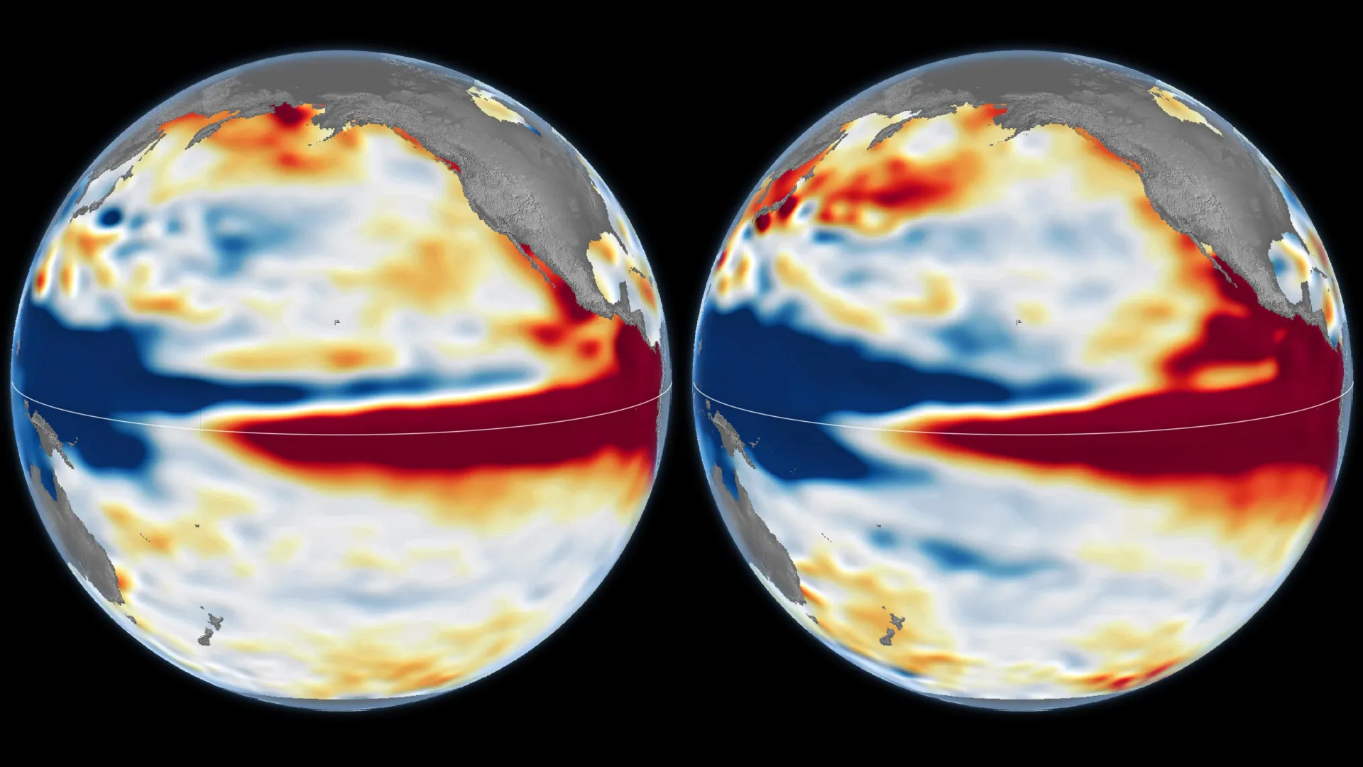
NASA scientists are tracking a rapidly strengthening El Niño in the equatorial Pacific that could grow large enough to rival, or potentially exceed, the landmark 1997–98 event. Satellite observations from October 2026 show sea levels higher than normal across the central and eastern equatorial Pacific, a signature associated with El Niño conditions.
The comparison matters because the 1997–98 El Niño was among the strongest in the modern observational record and was linked with major weather disruptions around the world. NASA says the current event shows striking similarities to that earlier episode, while stressing that the precise effects in individual regions cannot yet be known.
El Niño is a recurring climate pattern that generally develops every two to seven years. It begins when ocean temperatures become unusually warm across parts of the equatorial Pacific. Those ocean changes can alter atmospheric circulation, shifting rainfall, drought and storm patterns far beyond the Pacific basin.
Satellite records make the comparison possible
NASA researchers now have 35 years of satellite observations to examine the ocean conditions behind developing El Niño events. The October maps cited by NASA compare the 2026 Pacific with October 1997, showing elevated sea levels over broad areas of the central and eastern tropical Pacific in both cases.
Sea level is useful because warm water expands and can pile up in particular parts of the ocean. In the equatorial Pacific, the distribution of that warmer water offers scientists a way to follow the development of El Niño and compare an emerging event with previous ones.
The satellite record also lets researchers look beyond a single measurement. Ocean temperatures, the placement of warm water and the behavior of winds all form part of the evolving picture. That broader view is important because El Niño is not simply a period of warmer water; it is a coupled ocean-atmosphere phenomenon in which each part can reinforce the other.

How an El Niño gains strength
Under more typical Pacific conditions, trade winds push warm surface water westward. The warm water accumulates in the western Pacific, where the ocean surface is slightly higher than it is farther east. When those winds weaken, the arrangement begins to change.
Warm water can then move east across the Pacific. That movement may further weaken the trade winds, and in some cases the winds can reverse. The feedback allows more warm water to spread into the central and eastern Pacific, raising local sea level and sea-surface temperatures and strengthening the El Niño pattern.
NASA’s concern about the 2026 event rests on how quickly this process appears to be developing and on its resemblance to earlier major events. A close resemblance in October does not guarantee an identical outcome, but it gives forecasters a reason to watch the Pacific particularly closely through the coming months.
Past events show the range of potential consequences
Two of the strongest recent El Niño events occurred in 1997–98 and 2015–16. NASA notes that both were associated with widespread impacts, including destructive fires in Indonesia and the Amazon, severe drought and crop failures in southern Africa, and intense rainfall and coastal flooding in Southern California.
Those examples underline why a powerful El Niño commands attention well outside the tropics. Changes in the Pacific can affect the atmospheric circulation that helps shape weather across many regions. But the effects are not uniform, and no one historical event supplies a complete forecast for the next one.
Even if the 2026 pattern continues to intensify, local outcomes will depend on how the ocean and atmosphere evolve, as well as on other climate influences operating at the same time. NASA specifically notes that the exact impacts remain uncertain. That uncertainty is not a reason to dismiss the signal; it is a reminder that early monitoring must be paired with careful regional forecasting.

What to watch this winter
The developing event could bring a heightened risk of major rainfall and flooding in some areas during the coming winter, according to NASA’s assessment. The agency’s satellite comparisons provide an early warning framework rather than a region-by-region prediction.
For emergency planners, agricultural communities and residents in places historically affected by El Niño-driven weather, the emerging Pacific pattern is a reason to follow official seasonal outlooks closely. The strength of the ocean signal may be unusual, but the most consequential question is how that signal translates into regional weather.
The 2026 El Niño is still an evolving event. Its resemblance to 1997 is scientifically significant, yet its final intensity and its effects will be determined over time. The growing satellite record gives researchers a stronger basis for making those comparisons—and a clearer view of a climate pattern with global reach.
This article is based on reporting by Science Daily. Read the original article.
Originally published on sciencedaily.com