A striking image of weather and optics at once
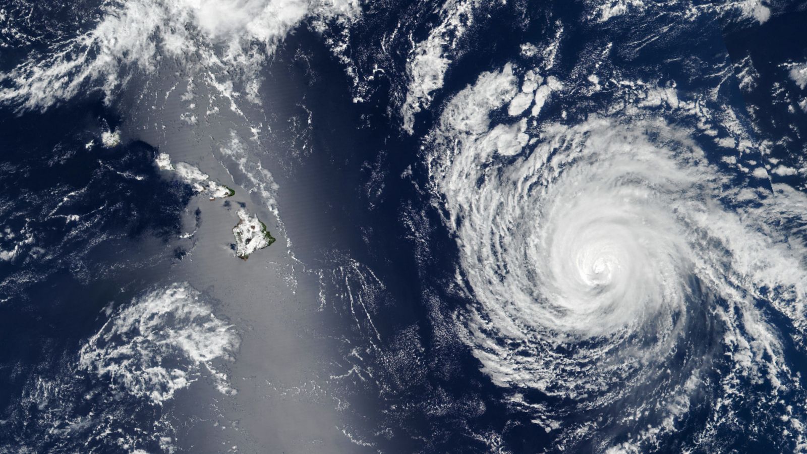
A satellite photograph taken in September 2025 captured an unusually dramatic scene over the central Pacific: Hurricane Kiko approaching Hawaii while the islands themselves were partly obscured by a bright silver band of reflected sunlight. The image, highlighted by Live Science, is visually arresting for obvious reasons, but it is also a useful reminder that satellite views of Earth are shaped not only by storms and clouds, but by geometry, light, and the reflective behavior of the ocean surface.
The picture was taken on September 7, 2025 by the Suomi NPP satellite. At the time, Kiko was about 600 miles east of Hilo on the Big Island, according to the reporting. The storm had formed in the eastern Pacific on August 31 and reached Category 4 strength by September 3, with peak winds around 145 miles per hour. That trajectory initially raised concerns that Hawaii could be directly in its path.
Why Hawaii looked like it was behind a sheet of metal
The silver streak stretching across the image is the result of a phenomenon called sunglint. In simple terms, sunglint occurs when sunlight reflects off the surface of water directly toward a satellite sensor. Under the right angle, the ocean behaves less like a matte blue surface and more like a mirror, producing a bright patch or band that can dominate the scene.
That is what happened here. The outlines of the Hawaiian Islands could still be made out inside the reflective zone, but the glare was strong enough to partially hide the islands from easy view. In many satellite images, sunglint is a nuisance if the goal is to see fine surface detail. In others, it becomes the most compelling feature in the frame, revealing something about viewing angle, surface roughness, and atmospheric conditions that would otherwise be invisible.

The storm was dangerous, but the worst outcome was avoided
Kiko was still a serious system when the image was captured. The cyclone was roughly 470 miles across at its widest point on September 7, according to NASA Earth Observatory information cited in the article. Yet the storm did not ultimately strike Hawaii at full power. The report says it weakened from a Category 4 to a Category 2 system before reaching the islands and shifted northward, passing mostly above the state before dissipating off the coast of Honolulu on September 10.
The reason given for the weakening and course change was that the hurricane encountered a patch of colder water. That interaction appears to have reduced the storm’s intensity enough that Hawaii was spared a more severe outcome. Residents still experienced heavy rainfall and high winds, but the source text says they were otherwise unaffected.
What makes sunglint scientifically useful
Although the image has the feel of a natural-art postcard, sunglint is not just a photographic oddity. In remote sensing, reflected light patterns can reveal information about the surface state of the ocean, including roughness and wave structure. A smooth area of water reflects differently than a choppy one, and satellites can exploit those differences depending on instrument type and observation goal.
That means the same phenomenon that hides a coastline from casual viewing can, under other circumstances, help scientists infer something about the environment. The public tends to notice sunglint because it makes familiar geography look surreal. Researchers notice it because it changes what satellites can and cannot see, and because that change contains information.

Why images like this resonate
There is also a reason scenes like this travel well beyond weather circles. The image compresses multiple scales of Earth observation into a single frame. A hurricane occupies the right side of the picture as a massive, organized atmospheric engine. On the left, a thin optical effect turns the Pacific into molten silver. Between them sits Hawaii, half visible, half hidden, caught between meteorology and sunlight.
That juxtaposition makes the image memorable, but it also sharpens a broader point about satellite literacy. Images from orbit can look transparent and objective, yet they are always products of timing, sensor characteristics, illumination, and interpretation. What appears to be a simple photograph is often a carefully assembled observational moment shaped by multiple physical processes at once.
A near miss preserved from orbit
For Hawaii, Kiko became a near miss rather than a disaster. For Earth-observation watchers, the storm left behind a vivid case study in how atmospheric events and surface optics can collide in the same image. The hurricane supplied the drama. The sunglint supplied the strangeness.
That combination is why the photograph stands out. It is not merely a storm image or a scenic satellite shot. It is a demonstration of how Earth systems look from space when weather, water, and sunlight briefly line up in just the right way. Hawaii was there all along. For one instant, the Pacific simply reflected too brightly for space to see it clearly.
This article is based on reporting by Live Science. Read the original article.

Originally published on livescience.com