Overview of Tyndall Glacier
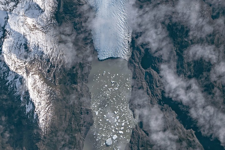
The Southern Patagonian Icefield, the largest expanse of ice in the Southern Hemisphere outside of Antarctica, stretches hundreds of kilometers along the Andes. It feeds dozens of dynamic outlet glaciers, including Tyndall Glacier in southern Chile. These glaciers often terminate in the sea or in proglacial lakes. On May 10, 2026, an astronaut aboard the International Space Station captured a striking image of Tyndall Glacier through a layer of ethereal clouds, showing fragments of ice that had calved off its terminus floating on Lago Geikie.
Glacial Retreat and Lake Formation
Like most Patagonian glaciers, Tyndall has been shrinking since the end of the Little Ice Age about 150 years ago. Lago Geikie formed at Tyndall's terminus around 1940, according to glaciologist Mauri Pelto of Nichols College, and gradually expanded as the ice retreated. Part of the glacier previously terminated in Lago Tyndall to the east, but thinning ice cut off that outlet by 2010. The ice's retreat also exposed bedrock along its eastern edge containing scores of ichthyosaur fossils.

Recent Ice Loss and Calving Events
Along with thinning, ice calving off the glacier's front has reduced its volume. Tyndall has lost 2.2 kilometers (1.4 miles) in length since November 2022, following about a decade of limited retreat with considerable thinning. A significant calving event in March and April 2023 contributed to the recent uptick in ice retreat, during which satellites observed several large icebergs breaking away from Tyndall's terminus.
Observations in Austral Autumn 2026
Austral autumn in 2026 was a time of active calving retreat at Tyndall and some neighboring glaciers, albeit more incremental than three years prior. Pelto noted that the substantial crevasses crisscrossing the glacier near the calving front lead to many smaller icebergs. In contrast, larger tabular icebergs tend to form when there are fewer deep crevasses near the terminus and the glacier's ice is thinner.
Significance of the Imagery
The astronaut photograph provides a unique perspective on the ongoing changes in Patagonian glaciers. Such imagery helps scientists monitor glacial dynamics and understand the impacts of climate change on these sensitive environments. The trail of icebergs across Lago Geikie serves as a visible reminder of the rapid transformations occurring in this region.
This article is based on reporting by science.nasa.gov. Read the original article.
Originally published on science.nasa.gov