Introduction: A Window into Deep Time
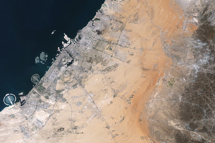
About an hour's drive east of Dubai's gleaming towers and artificial islands, a quieter, more natural landscape takes shape. At the far northern edge of the Rub' al Khali, a saffron-colored sand sea laps against the Al-Hajar Mountains. A series of pale ridges rises finlike from the desert plain, with the largest—Jabal al Fāyah—standing 412 meters (1,352 feet) above sea level. The Landsat 8 satellite captured this image of the ridges cutting across the Emirate of Sharjah in the northern part of the United Arab Emirates on October 23, 2025. To geologists, the limestone ridges are a reminder of the region's watery past, signs that this land lay underwater tens of millions of years ago when the sedimentary rock layers were deposited.
Geological Significance of Jabal al Fāyah
Jabal al Fāyah functions as a barrier, trapping windblown sand in dune fields to its west. The weathering of iron-bearing minerals in the sand grains gives the dune fields their orange hue. To the east, the branching channels of overlapping alluvial fans extending from the Al-Hajar Mountains carry gravels and eroded sediments from basalts and other dark mafic rocks. The dark rocks to the east—part of the Samail Ophiolite—are known to geologists for being among the world's largest, best-preserved, and most accessible exposures of ancient oceanic lithosphere, the rigid outer layer of Earth that includes both the crust and upper mantle. Oceanic lithosphere like this is normally subducted and recycled back into the mantle when tectonic plates collide. But in this area, a large section from beneath the Tethys Sea was scraped off and thrust onto the Arabian plate in a process called obduction.
The Limestone Ridges: A Record of Ancient Seas
The limestone ridges that include Jabal al Fāyah were formed from the accumulation of marine sediments on the floor of the Tethys Sea, which once covered much of the Middle East. Over millions of years, these sediments hardened into rock, and tectonic forces later uplifted them to form the ridges we see today. The presence of marine fossils within the limestone further confirms that this arid landscape was once submerged. This geological history is not just a curiosity; it provides critical insights into the region's past climate and environmental changes, which in turn influenced human migration and settlement patterns.

Human History and Archaeological Importance
Jabal al Fāyah is not only a geological landmark but also an archaeological treasure. The area has yielded some of the oldest evidence of human occupation in the Arabian Peninsula, with stone tools and other artifacts dating back to the Paleolithic period. These findings suggest that early humans used the ridge as a lookout point and a source of raw materials for toolmaking. The site's location near freshwater springs and its elevation would have made it an ideal refuge during periods of climatic fluctuation. The presence of early human artifacts at Jabal al Fāyah underscores the adaptability of our ancestors, who thrived in a landscape that transitioned from lush savanna to arid desert over millennia.
Connecting Geology and Archaeology
The same geological processes that created the limestone ridges also shaped the environment that early humans inhabited. The alluvial fans to the east provided fertile soils and water sources, while the ridge itself offered shelter and strategic vantage points. The interplay between geology and human history at Jabal al Fāyah makes it a unique site for interdisciplinary research, combining earth science with archaeology to reconstruct past landscapes and human behaviors.
Modern Observations from Space
The Landsat 8 satellite, equipped with the Operational Land Imager (OLI), captured the image of Jabal al Fāyah on October 23, 2025. This image not only highlights the stark contrast between the orange sand dunes and the pale limestone ridges but also reveals the intricate drainage patterns of the alluvial fans. Satellite imagery like this is invaluable for monitoring changes in desert landscapes, such as dune migration and erosion, and for identifying archaeological sites that may be hidden beneath the sand. The NASA Earth Observatory's Image of the Day feature brings such observations to the public, fostering appreciation for the dynamic processes shaping our planet.
Broader Implications for Climate and Human Survival
The story of Jabal al Fāyah is a microcosm of the broader narrative of climate change and human resilience. As the Arabian Peninsula dried out after the last ice age, early humans had to adapt to increasingly harsh conditions. Sites like Jabal al Fāyah served as refugia where water and resources remained available, allowing populations to persist and eventually develop the complex societies that built the cities of today. Understanding these past adaptations can inform current strategies for coping with climate change, particularly in arid regions where water scarcity is a growing concern.
Conclusion: A Timeless Landscape
Jabal al Fāyah stands as a silent sentinel over the Rub' al Khali, its limestone ridges bearing witness to a dynamic Earth history spanning tens of millions of years. From the depths of the Tethys Sea to the heights of a desert peak, this landmark encapsulates the interplay of geology, climate, and human endeavor. As satellite technology continues to reveal the secrets of our planet, sites like Jabal al Fāyah remind us of the deep time connections that shape our world and our place within it.
This article is based on reporting by science.nasa.gov. Read the original article.
Originally published on science.nasa.gov