A dune field many people never think about
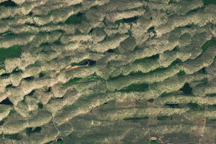
When people picture major dune systems, they usually imagine coasts or deserts. Nebraska’s Sandhills challenge that intuition. In a new Earth Observatory feature, NASA highlights the region as the largest system of sand dunes in the Western Hemisphere, stretching across about one-quarter of the state. The imagery, acquired by the Operational Land Imager on Landsat 8 in August 2025, offers a reminder that one of North America’s most striking landforms exists far from the settings most people associate with dunes.
The landscape lies across north-central Nebraska and covers roughly 20,000 square miles, or about 52,000 square kilometers. What appears at first glance to be broad grassland is, in fact, an immense field of stabilized dunes. Grasslands cloak the rolling topography, while lakes and wetlands break up the terrain and support plant and animal life. The region is therefore both geologically dramatic and ecologically productive.
How a dune sea formed in the middle of the continent
NASA’s account traces the origins of the Sandhills back to material eroded from the Rocky Mountains. Rivers carried that sand eastward and spread it across the Great Plains during the Pleistocene. Later, drought conditions left riverbeds dry enough for winds, blowing mainly from the north or south, to lift and reshape the sand into dunes.
That history matters because it explains why the Sandhills do not look like a conventional desert. They are the product of transport, deposition, drought, and windworking across deep time, followed by stabilization. Around 3,500 years ago, grassland vegetation anchored the dunes, locking a once-mobile landscape into the rippled form visible today.
The result is a rare combination: a dune system that remains unmistakable in shape yet is covered largely by vegetation rather than exposed sand. That makes the Sandhills visually subtler than iconic desert dune fields, but no less impressive in scale.

What the satellite imagery reveals
The Earth Observatory image shows how extensive and patterned the region is from above. NASA notes that some of the largest dunes occur in the northwestern part of the Sandhills. In the detailed view highlighted by the agency, transverse dunes rise as high as 400 feet, or about 120 meters, and can extend for several miles.
Those dunes also preserve a record of wind behavior. Their northern slopes are gentler than their southern slopes, which NASA says reflects the dominant influence of northerly winds. Elsewhere, more symmetrical dunes suggest that winds from the north and south alternated with roughly equal strength across the seasons. In other words, the shape of the land is also a record of atmospheric pattern.
This is one reason satellite observation is so valuable. From the ground, much of the Sandhills can read as rolling rangeland. From orbit, the structure becomes legible: long dune forms, organized ridges, and the unmistakable geometry of an ancient sedimentary system still visible beneath the grass.
A working landscape as well as a geologic archive
NASA’s description emphasizes that the Sandhills are not just a scenic curiosity. The grasslands provide grazing grounds for livestock, while the lakes and wetlands support diverse ecosystems. That dual identity is part of what makes the region important. It is both an active human landscape and a preserved natural archive of past climate and geomorphic change.
Places like the Sandhills complicate the common divide between natural wonder and working land. The same features that speak to ancient river systems, droughts, and wind regimes also shape how people use the land today. The result is a region whose scientific value and economic role coexist rather than compete.

Why Earth observation stories like this matter
At first glance, an Earth Observatory image of Nebraska may seem modest beside stories about rockets, lunar missions, or planetary discoveries. But Earth science often works by making the familiar strange again. The Sandhills are a case study in how remote sensing can reveal overlooked scale, hidden process, and long-duration environmental history in a place that many observers might otherwise pass over.
Landsat’s long-running record is especially useful for this kind of interpretation. It allows scientists and the public to study landforms, vegetation, and hydrology across broad areas with a consistency that ground observation alone cannot match. In the Sandhills, that perspective helps show how a landscape formed by ancient sediment transport and wind has become a stable, living system.
The story is also a reminder that some of the most extraordinary geographies are not necessarily the most famous. Nebraska’s Sandhills do not fit the popular image of an inland dune sea, which may be one reason they remain underappreciated outside scientific and regional circles. Yet by area, they stand at the top of their class in the Western Hemisphere.
A quieter kind of space story
Seen through NASA’s lens, the Sandhills become part of a larger space-based project: understanding Earth by observing it from above. The agency’s imagery turns a broad sweep of rangeland into a visible geologic narrative, one written in ridges, slopes, wetlands, and stabilized sand.
That makes this a quieter kind of space story, but a meaningful one. Not every revelation from orbit points outward. Some of the most useful ones point back at the planet, showing how much complexity can hide inside landscapes that seem, at first glance, ordinary. Nebraska’s wide, rolling domain is one of them.
This article is based on reporting by science.nasa.gov. Read the original article.

Originally published on science.nasa.gov