A hidden freshwater system below a hypersaline lake
Scientists have identified what may be a vast freshwater reservoir beneath Utah’s Great Salt Lake, adding an unexpected layer to one of North America’s most intensively studied inland water systems. According to the reported findings, the freshwater body extends as deep as 2.5 miles, and its footprint may match or even exceed the surface area of the lake above it.
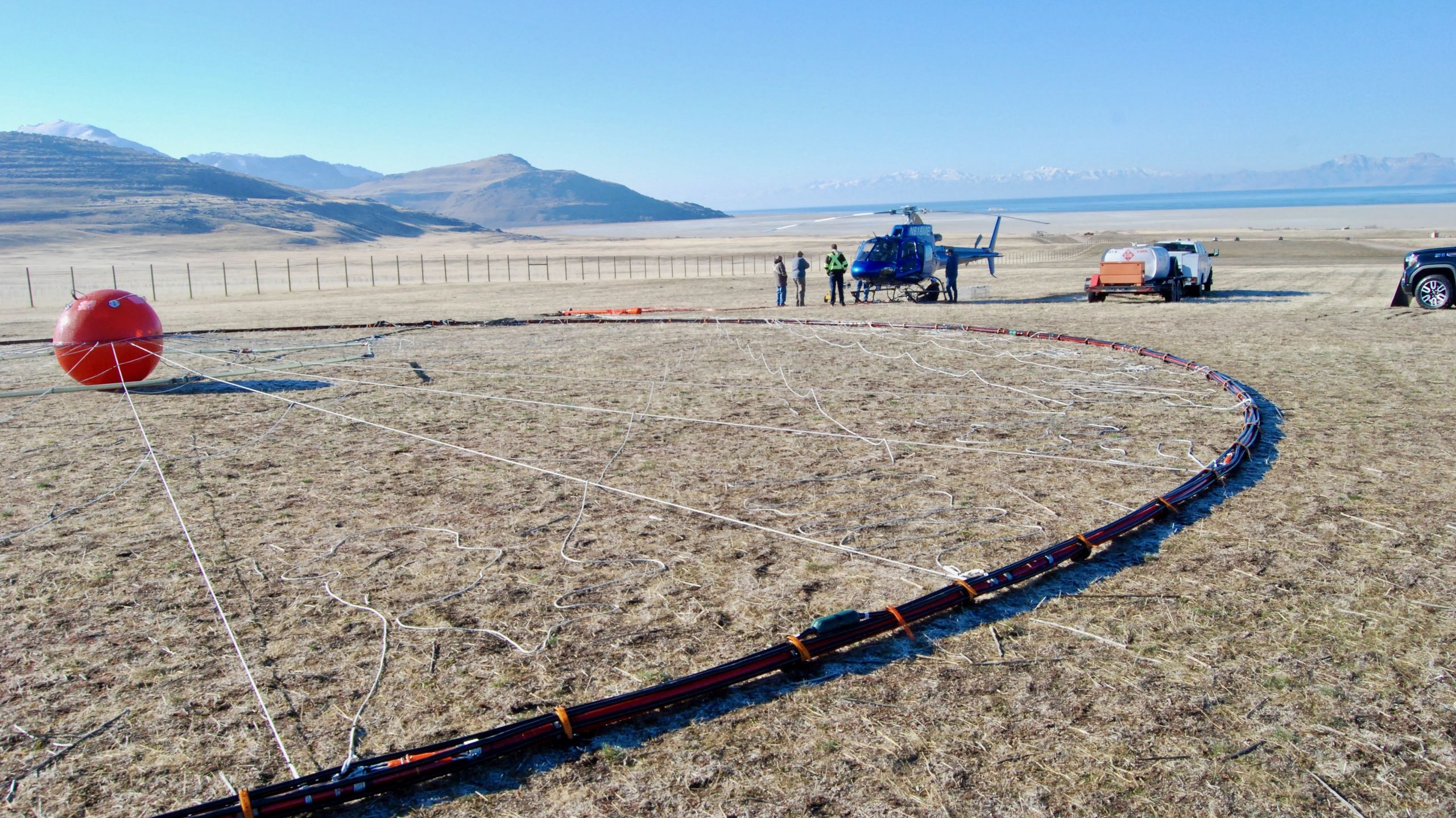
The discovery was made with an airborne electromagnetic survey, a technique that allows researchers to infer underground water distribution by measuring differences in electrical conductivity. That approach is particularly useful in a place like Great Salt Lake, where saltwater and freshwater create strong contrasts underground. The result is a new picture of the basin: not simply a shallow saline lake resting on sediments, but a more complex hydrologic structure with potentially significant freshwater storage beneath it.
Why the finding matters
Great Salt Lake has become a symbol of water stress in the U.S. West, with falling lake levels raising concerns about ecosystem damage, dust pollution, mineral extraction, and long-term water management. A buried freshwater system does not solve those problems on its own, but it may change how researchers think about the region’s subsurface hydrology.
The significance is scientific first. A freshwater body of this scale suggests that water movement through the basin is more active and more layered than a simple surface model would imply. It may also help explain long-observed but poorly constrained interactions among mountain runoff, basin sediments, groundwater flow, and the saline lake.
Any practical implications will depend on follow-up work. A large underground reservoir is not automatically a usable water supply. Questions remain about recharge rates, water quality, hydraulic connection to the lake, legal access, and the environmental consequences of any extraction. Still, identifying the reservoir is an important step because it establishes that the basin may hold more freshwater underground than previously recognized.
How researchers mapped it
The reporting indicates that the team used airborne electromagnetic surveying to map freshwater deposits beneath the lake. In broad terms, the system sends electromagnetic signals into the ground and measures the returning response, which varies depending on whether the subsurface contains more conductive salty water or less conductive fresh water.
This is an especially strong fit for Great Salt Lake. The lake’s briny waters create a clear geophysical contrast against buried freshwater, making the method suitable for identifying deep and laterally extensive zones that would be difficult to detect with sparse drilling alone. By flying the survey over the basin, researchers could build a regional map rather than rely on a limited number of point measurements.
The resulting model points to a freshwater layer extending well below the surface, reportedly down to around 4 kilometers. That depth, combined with the possible lateral extent, is what makes the finding so striking.
A basin still full of unanswered questions
The discovery opens a new set of research questions. Scientists will want to know where the freshwater comes from, how old it is, how quickly it is replenished, and how strongly it is connected to present-day climate and runoff. If the water accumulated over long timescales under different climatic conditions, its management implications would be very different from those of a rapidly recharged aquifer.
Researchers will also need to determine how the freshwater body interacts with the lake itself. In closed basins, groundwater can influence salinity patterns, sediment chemistry, and lake-level dynamics. If subsurface flows are feeding or buffering parts of the lake system, that could matter for future models of the region’s environmental decline.
There is also a policy dimension. Water-stressed regions often treat any newly identified underground supply as a potential resource, but subsurface water in fragile basins can be ecologically important even when it is not directly visible. A more complete understanding of the reservoir could therefore become relevant not only to hydrologists, but also to state regulators, conservation planners, and communities already dealing with the consequences of shrinking surface water.

A reminder that major discoveries can still emerge from familiar places
Great Salt Lake is not a remote frontier. It sits beside a major metropolitan corridor and has been observed for decades. That makes the discovery notable in another way: it shows that even heavily monitored landscapes can still hold large-scale surprises below ground.
For now, the main conclusion is careful rather than sensational. Scientists have found evidence of a potentially enormous freshwater reservoir beneath the lake, and the scale alone makes it important. What it means for water supply, lake management, and regional ecology will depend on the next round of measurements and interpretation. But the finding already changes the conversation by revealing that one of the West’s most stressed water systems may be underlain by a much larger and more complicated hidden one.
This article is based on reporting by Live Science. Read the original article.
Originally published on livescience.com