Google无法看到的城市
美国每一个有重要意义的城市和城镇都被Google Street View相机拍摄过——除了一个:明尼苏达州North Oaks。这个位于St. Paul以北的富裕郊区在Street View上保持隐形已近二十年,不是因为技术障碍,而是因为一个不寻常的产权结构——这个结构将道路及其所有访问权限掌握在居住在那里的房屋所有者手中。
North Oaks是约5000名居民的家园,其中许多人是总部设在Twin Cities的大型企业高管。前副总统Walter Mondale曾住在那里。这个地方按设计是抵制审视的——并且超过十五年来,它一直成功地抵制了Google的相机。
隐形的法律结构
与美国几乎所有其他市政区不同,在那些地方道路是政府拥有的公共通行权,North Oaks的街道由North Oaks房屋所有者协会所有。每个房屋所有者的财产延伸到相邻道路的中心,这意味着城市中实际上没有公共用地。入口处的标志明确表示,未经许可驾驶这些道路构成侵入。自动车牌读取器捕获进入的车辆身份。
当Google Street View汽车在该计划早期进入这座城市时,该市威胁采取法律行动进行侵入起诉。Google遵从了,删除了这些图像,并且此后没有再来过。

纪录片制作人发现了漏洞
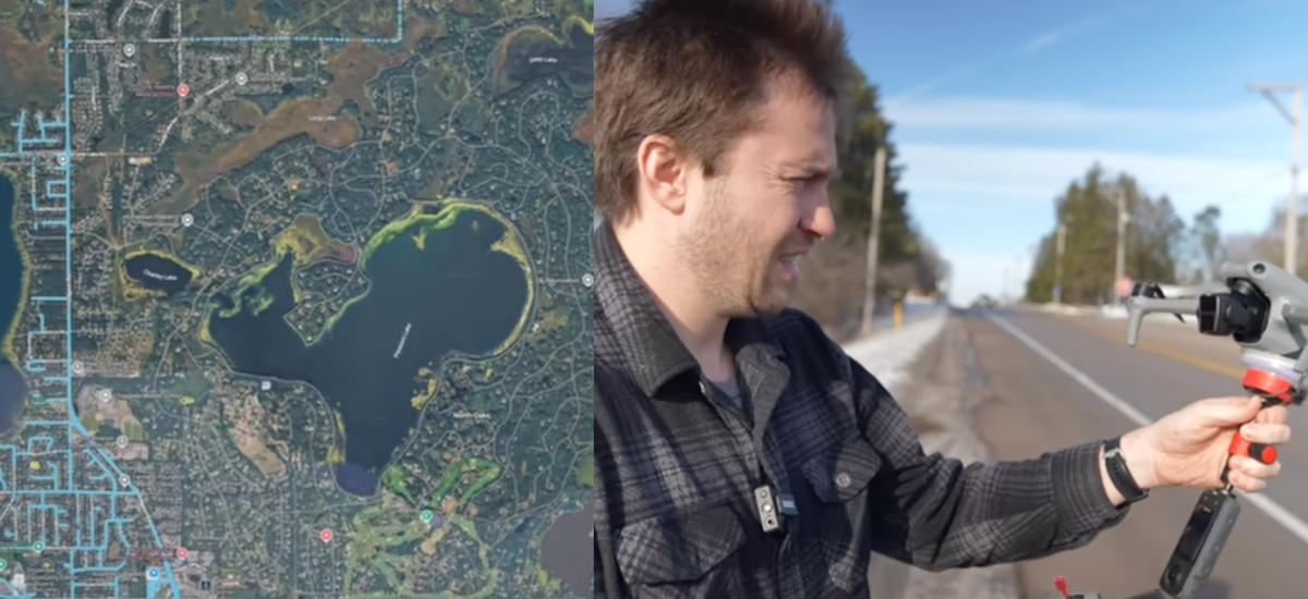
Chris Parr在North Oaks附近长大,长期以来一直被这座城市精心维护的匿名性所吸引。他发现了一条房屋所有者协会显然没有考虑的法律途径:North Oaks上方的领空由联邦航空管理局(FAA)管辖,而不是由当地产权所有者管辖。
"从技术上讲,任何拥有注册无人机飞行员证书的人都可以从公共财产上发射无人机,直接飞往私人财产上空," Parr解释道。NOHOA的财产权主张延伸到地面上道路的中心——而非延伸到上方的天空。
Parr驾车前往该城市的边界,从公共道路肩部发射无人机,将其飞越North Oaks的街道、住宅和公园。他捕捉了大量航拍素材,并将这些图像上传到Google Maps,填补了之前明显的空白。在短暂的时间内,North Oaks变成了可以在地图上看到的城市。用户首次自2008年以来可以在Street View上导航其街道。
短暂的胜利及其后果
这个实验没有持续下去。居民和房屋所有者协会迅速标记了Parr的图像,Google删除了它们。Parr收到了代表NOHOA的律师事务所的信函——不是要求他删除自己的素材,而是通知他不欢迎他再次回访。
一些街道距离边界太远,Parr无法从公共用地到达。为了完成他的映射,他在Craigslist上发帖寻求愿意邀请他进来的居民,收到了大量回应,并与一位名叫Maggie的女性建立了联系,她允许他访问城市内的一个公园。带上邀请和无人机,他在地图被删除之前完成了映射。

隐私、财富和映射的未来
North Oaks的故事颠倒了美国生活中通常的监视动态。大多数社区没有机制来抵制被拍摄、追踪或映射。他们的街道是公共的。他们居民的行动由Ring摄像头、CCTV和车牌读取器记录,没有有意义的同意。North Oaks通过其不寻常产权结构的意外收获,获得了美国任何其他社区都无法获得的集体隐私程度。
Parr的纪录片对此是否正当并未采取坚定立场。"我知道我能够做到这一点,但我不知道我是否应该能够做到这一点,这就是我想解决的问题," 他说道。根据他的描述,YouTube上对他视频的评论大致分为50-50,一半的人认为他的映射是透明度的胜利,另一半认为这是对合法隐私的侵犯。
这一事件提出的问题超越了一个富裕郊区。随着无人机技术变得更便宜,AI驱动的图像处理也使航拍素材变得更加有用,任何产权所有者抵抗外部监视的能力将继续削弱。North Oaks可能是最后一个成功维持其隐形状态的美国城市——但使这成为可能的法律和技术工具不太可能长时间保持有效。
这篇文章基于404 Media的报道。阅读原始文章。
Originally published on 404media.co