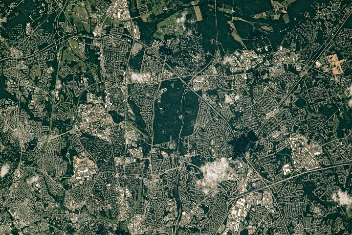
A suburban landscape built around roads still carries a strong green structure
NASA’s latest Earth Observatory image turns a familiar metropolitan edge into a study in urban form. The photograph, taken from the International Space Station and published as an Image of the Day, looks at the northeastern side of the Capital Beltway where it passes through Greenbelt, Maryland. What stands out is not just development, but the persistence of green space woven through it.
The scene is from July 30, 2023, when vegetation in the region was at its summer peak. That timing matters. At full leaf, the area’s parks, wooded corridors, research lands and tree-lined neighborhoods become more legible from orbit, revealing a metropolitan pattern that is less continuous sprawl than a patchwork of built zones interrupted and shaped by green land.
NASA’s framing is modest, but the image captures something important about the Washington suburbs: infrastructure and planning decisions made over decades still determine where green space survives, how communities are organized, and where institutional land uses create buffers against continuous development.
Greenbelt Park anchors the image
The most prominent green area in the published view is Greenbelt Park, a nearly 5-square-kilometer tract of forest containing hiking trails, picnic areas and a campground. According to NASA, the land had once been intended as a future extension of the city of Greenbelt before the National Park Service acquired it in 1950.
That history gives the park an unusual role. It is not simply a preserved natural area on the fringe of development. It is land that might have been urbanized but instead became a lasting interruption in the suburban fabric. In the image, the park reads as a broad, dark green mass set within a highly developed corridor tied together by Interstate 495.
In practical terms, spaces like that alter how growth unfolds around them. They shape road patterns, preserve tree canopy, influence local cooling and recreation, and create a visual identity that many suburban landscapes lose as they densify. NASA’s image does not attempt to quantify those effects, but it makes their spatial importance obvious.
A New Deal planned community remains visible from space
North of the park, NASA points to Greenbelt’s historic district, laid out in a crescent shape. The district is one of three planned communities established in the 1930s under the New Deal. The intention was not only to provide work for the unemployed but to create affordable cooperative housing with accessible green space.
That planning legacy is still readable in the urban pattern. Homes connect to walking paths, and those paths connect to one of the oldest planned shopping centers in the United States. From the ground, those details belong to local planning history. From orbit, they become evidence that a neighborhood designed around open space and pedestrian connection can remain structurally distinct long after the era that created it.
The publication of the image on Earth Day underscores the point without overplaying it. In many US metro areas, green space survives as leftover land or fragmented remnants. In Greenbelt, some of it is foundational to how the community was first conceived.
Research campuses and agricultural land expand the corridor of open space
The image also places Greenbelt within a broader institutional landscape. East of the beltway is NASA’s Goddard Space Flight Center, established in Greenbelt on May 1, 1959, as NASA’s first spaceflight complex. NASA notes that patches of forested land separate some of the center’s buildings, adding to the broken but persistent chain of green visible in the scene.
North of Goddard, the land in Beltsville includes a mix of forests and agricultural fields associated with University of Maryland and USDA research sites. That combination is a reminder that not all urban green space is parkland. Some of it persists because of scientific, educational or agricultural use, and those land uses can preserve large open tracts in places where the market might otherwise produce a more continuous built environment.
Just west of Greenbelt, the University of Maryland’s main campus in College Park is also visible. South of there, Hyattsville has been recognized as a “tree city” for more than three decades, according to NASA. Even transportation corridors contribute to the broader visual pattern, with trees lining a significant stretch of the Baltimore-Washington Parkway.

An orbital image with a local planning lesson
None of this makes the Washington suburbs an ecological ideal. The image is still centered on a major highway ring serving a dense metropolitan area, and the surrounding development is unmistakable. But the photograph illustrates how metropolitan growth does not erase every earlier planning choice. Parks, planned communities, federal campuses, agricultural research land and tree-focused municipal policies all continue to leave marks that are visible even from the International Space Station.
That is what gives this otherwise quiet NASA image broader relevance. It offers a compact map of how multiple eras of policy and institution-building overlap in one suburban corridor: New Deal housing design, postwar park acquisition, the rise of federal science infrastructure, and the preservation of agricultural research land. Together, those layers created belts of green within one of the country’s busiest urban regions.
Earth Observatory’s Image of the Day series often turns ordinary places into useful case studies. Here, the lesson is that green space in developed regions is rarely accidental. It is planned, protected, repurposed, or institutionally anchored. In northeastern Washington’s suburbs, those decisions have produced a landscape where roads and roofs dominate, but do not fully define, the view.
This article is based on reporting by science.nasa.gov. Read the original article.
Originally published on science.nasa.gov
](https://www.universetoday.com/article_images/noirlab2510a_dp.jpg_20260720_214642.webp)