A classic geology mystery gets a new contender
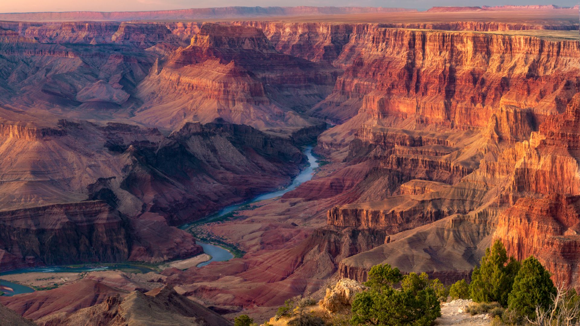
The Grand Canyon is one of Earth’s most iconic landforms, but geologists have long disagreed over exactly how the Colorado River established the path that would eventually cut through northern Arizona. A new study adds a dramatic scenario to that debate: before the river fully integrated through the region, water may have pooled into a giant lake and then spilled over, helping launch the canyon-carving process.
The idea, as summarized in the new reporting, is that the Colorado River did not simply muscle its way across the landscape in a steady, uninterrupted fashion. Instead, water may have accumulated behind barriers, forming a major lake system that eventually overtopped its bounds and began eroding downstream. Once that spillover began, the river could have accelerated incision and established a through-going route.
It is an appealing story because it combines tectonics, drainage evolution, and catastrophic release into one coherent origin sequence. But the reporting also makes clear that not everyone agrees with the conclusion, which means the Grand Canyon’s early history remains an active scientific argument rather than a settled narrative.
Why the origin question has lasted so long
Part of the difficulty lies in the canyon’s age, scale, and geological complexity. Rivers evolve over millions of years, landscapes uplift, sediments are removed or reworked, and older surfaces can be partially erased by later erosion. That makes it hard to reconstruct not just when incision happened, but how a drainage system first connected across the region.
The Colorado River seen today is the product of a vast watershed. The question is how those different pieces became linked strongly enough for water to move through what is now the Grand Canyon and deepen it into the landform known today. A spillover-lake hypothesis offers one answer: connection occurred when an accumulated body of water exceeded a threshold and carved a route through.
Such processes are not exotic in geology. Lakes can breach natural barriers, and spillover events can reorganize drainage quickly. The challenge is proving that this is what happened here, in this place, at this scale.
The new case for pooling and spillover
According to the new research cited in the report, scientists found evidence suggesting the Colorado River pooled in a giant lake before eventually spilling out and carving the Grand Canyon. The proposed lake would have occupied part of what is now northern Arizona.
The significance of that sequence is twofold. First, it implies that a large standing body of water existed where a through-flowing river had not yet fully established itself. Second, it frames canyon initiation as a threshold event, where spillover and downstream erosion became the mechanism that integrated the drainage system.
That does not mean the entire canyon appeared suddenly. Carving a feature as immense as the Grand Canyon would still involve prolonged erosion over geologic time. But the new hypothesis suggests the initial breakthrough may have been far more dramatic than a simple model of gradual headward erosion alone.
Why geologists may hesitate
The article’s caveat that not everyone agrees is important. Grand Canyon formation has attracted multiple competing or overlapping explanations over time, and new evidence often has to be weighed against older interpretations of uplift, sediment records, river integration timing, and regional topography.
A spillover model can be persuasive, but it must account for several questions:
- What physical barrier held the lake in place?
- How large and long-lived was the proposed lake?
- What geological evidence best distinguishes a spillover event from slower river integration?
- How does the model fit with previous age estimates and erosional histories for different parts of the canyon?
These are not trivial issues. In major landscape evolution problems, several mechanisms can leave partially similar traces, and researchers often disagree over which sequence best fits the evidence.
What makes the hypothesis compelling anyway
Even with debate unresolved, the lake-spillover explanation is compelling because it gives the public an intuitive way to picture a notoriously complicated geological process. Instead of imagining the canyon as the inevitable result of one river steadily grinding downward under a single set of conditions, the new study emphasizes instability, accumulation, and breakthrough.
That kind of threshold behavior is common in Earth systems. Landscapes can remain in one configuration for long intervals and then change rapidly when a barrier fails, drainage reroutes, or erosion crosses a tipping point. In that sense, the proposed Grand Canyon origin story fits a broader geological principle: some of the planet’s most famous features emerge from a combination of slow buildup and abrupt transition.
It also reinforces that large rivers are not always born fully connected. They are assembled over time from basins, captures, blockages, and releases.
A reminder that iconic landscapes still hold basic questions
It is easy to think of a place as well known as the Grand Canyon as thoroughly explained. The opposite is often true. Famous landscapes attract repeated investigation precisely because they preserve long, complicated histories that are hard to read cleanly. New methods, new field observations, and new syntheses can all reopen questions that seemed stable.
The latest study does not end the debate, but it does sharpen it. If the Colorado River really pooled into a giant lake and then spilled downstream, the canyon’s origin may owe more to a dramatic hydrological breakthrough than many simplified accounts suggest.
If that interpretation does not hold up, the value of the work remains in forcing the field to test origin models more rigorously. Either way, the canyon continues to serve as a reminder that geology rarely offers one clean beginning for a landform of this size.
The bigger scientific value
Beyond the Grand Canyon itself, research like this matters because drainage integration and landscape incision are fundamental Earth science problems. Understanding how rivers connect, breach barriers, and reorganize terrain helps scientists interpret mountain building, sediment transport, paleoenvironments, and even hazard processes in other settings.
The new proposal therefore resonates beyond Arizona. It is part of a broader effort to understand how large surface systems transition from one state to another, and how evidence for those transitions survives in rock and topography.
For now, the central takeaway is straightforward: a new study argues that the Colorado River may have first pooled into a giant lake, then spilled over and helped carve the Grand Canyon. The idea is vivid, plausible enough to matter, and contested enough to keep the mystery alive.
This article is based on reporting by Live Science. Read the original article.
Originally published on livescience.com