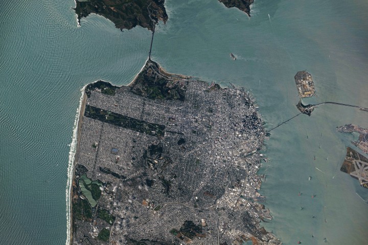
Overview of the Image
On May 27, 2026, an astronaut aboard the International Space Station captured a remarkable photograph of San Francisco and the surrounding Bay Area. The image, taken during a break in unsettled weather that brought scattered showers and thunderstorms to the region, reveals the city's iconic landmarks and intricate urban layout from a unique nadir perspective.
Iconic Bridges
The photograph prominently features two of the region's most famous bridges. The Golden Gate Bridge connects the northern San Francisco Peninsula with Marin County to the north, while the San Francisco-Oakland Bay Bridge spans the bay eastward toward Oakland. These structures are vital transportation links and symbols of the area's engineering prowess.
Green Spaces Amid Urban Density
Near the center of the image, Golden Gate Park stands out as a long, rectangular strip of green amidst the dense urban landscape. Spanning more than 1,000 acres (400 hectares), the park includes meadows, gardens, wooded areas, and lakes. Additional green space near the Golden Gate Bridge is part of a national recreation area, providing residents and visitors with ample opportunities for outdoor activities.
Urban Development and Street Grids
The nadir perspective offers a clear view of the patchwork of street grids laid out over San Francisco's hilly terrain. As the city grew in successive stages, these grids were adapted to the topography. Market Street runs southwest to northeast through the heart of downtown, serving as a prominent divider between two distinct grid orientations: one aligned with the bay and the other aligned with the street itself.
Maritime Activity and Waterfront
Along the northeastern and eastern waterfront, various structures extend into the bay. These include a historic wharf, seawalls, and piers, most built in the early 1900s, though some date back to the 1800s. The adjacent waters support heavy maritime traffic, including cargo and container ships, cruise vessels, and regional ferries. This bustling port activity underscores San Francisco's role as a major economic hub.
Coastal Features and Weather Conditions
Breaking waves are visible along the western coast, including at Ocean Beach, a 3.5-mile stretch of sandy shore adjacent to Golden Gate Park. On May 27, the National Weather Service warned of hazardous conditions at the region's beaches due to strong northerly winds and long-period swells from the north. This highlights the dynamic weather patterns that characterize the Bay Area.

Conclusion
This astronaut photograph provides a comprehensive view of San Francisco's metropolitan mosaic, blending urban development, green spaces, and maritime activity. It serves as a testament to the city's rich history and ongoing evolution, captured from a vantage point only accessible from space.
This article is based on reporting by science.nasa.gov. Read the original article.
Originally published on science.nasa.gov