Eine um Straßen herum gebaute Vorortlandschaft behält eine starke grüne Struktur
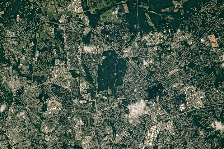
Das neueste Earth-Observatory-Bild der NASA macht aus einem vertrauten metropolitanen Randraum eine Studie urbaner Form. Das Foto, aufgenommen von der Internationalen Raumstation und als Bild des Tages veröffentlicht, richtet den Blick auf die nordöstliche Seite des Capital Beltway, wo er durch Greenbelt in Maryland verläuft. Auffällig ist nicht nur die Bebauung, sondern die anhaltende Präsenz von Grünflächen, die in sie eingewoben sind.
Die Szene stammt vom 30. Juli 2023, als die Vegetation in der Region ihren sommerlichen Höhepunkt erreichte. Dieser Zeitpunkt ist wichtig. Bei vollem Laub werden Parks, bewaldete Korridore, Forschungsgelände und von Bäumen gesäumte Wohnviertel aus der Umlaufbahn besser erkennbar und offenbaren ein metropolitanes Muster, das weniger einer kontinuierlichen Ausbreitung als vielmehr einem Flickenteppich aus bebauten Zonen ähnelt, die von Grünflächen unterbrochen und geformt werden.
Die Darstellung der NASA ist nüchtern, doch das Bild hält etwas Wichtiges über die Vororte von Washington fest: Infrastruktur und Planungsentscheidungen, die über Jahrzehnte getroffen wurden, bestimmen weiterhin, wo Grünraum erhalten bleibt, wie Gemeinden organisiert werden und wo institutionelle Flächennutzungen Puffer gegen fortlaufende Bebauung schaffen.
Greenbelt Park verankert das Bild
Die markanteste Grünfläche in der veröffentlichten Ansicht ist der Greenbelt Park, ein Waldgebiet von fast 5 Quadratkilometern mit Wanderwegen, Picknickbereichen und einem Campingplatz. Laut NASA war das Land einst als zukünftige Erweiterung der Stadt Greenbelt vorgesehen, bevor der National Park Service es 1950 erwarb.
Diese Geschichte verleiht dem Park eine besondere Rolle. Er ist nicht einfach ein geschütztes Naturgebiet am Rand der Bebauung. Es handelt sich um Land, das hätte urbanisiert werden können und stattdessen zu einer dauerhaften Unterbrechung im vorstädtischen Gefüge wurde. Im Bild erscheint der Park als breite, dunkelgrüne Masse innerhalb eines stark entwickelten Korridors, der durch den Interstate 495 verbunden ist.
Praktisch verändern solche Räume die Art und Weise, wie Wachstum sich um sie herum entfaltet. Sie prägen Straßennetze, erhalten die Baumkronen, beeinflussen lokale Kühlung und Erholung und schaffen eine visuelle Identität, die viele Vorortlandschaften bei zunehmender Verdichtung verlieren. Das NASA-Bild versucht diese Effekte nicht zu quantifizieren, macht ihre räumliche Bedeutung aber deutlich.

Eine New-Deal-Planstadt bleibt aus dem All sichtbar
Nördlich des Parks verweist NASA auf das historische Viertel von Greenbelt, das in halbmondförmiger Anordnung angelegt ist. Das Viertel ist eine von drei in den 1930er Jahren im Rahmen des New Deal gegründeten Planstädten. Ziel war nicht nur, Arbeitslose zu beschäftigen, sondern bezahlbaren genossenschaftlichen Wohnraum mit zugänglichen Grünflächen zu schaffen.
Dieses planerische Erbe ist noch immer im städtischen Muster lesbar. Häuser sind mit Fußwegen verbunden, und diese Wege führen zu einem der ältesten geplanten Einkaufszentren der Vereinigten Staaten. Vom Boden aus gehören solche Details zur lokalen Planungsgeschichte. Aus der Umlaufbahn werden sie zum Beleg dafür, dass ein Viertel, das um Freiraum und Fußwege herum entworfen wurde, auch lange nach seiner Entstehungszeit strukturell eigenständig bleiben kann.
Die Veröffentlichung des Bildes am Earth Day unterstreicht diesen Punkt, ohne ihn zu übertreiben. In vielen US-Metropolregionen bleibt Grünraum als Restland oder fragmentarische Überbleibsel erhalten. In Greenbelt ist ein Teil davon grundlegend für die ursprüngliche Konzeption der Gemeinde.
Forschungscampusse und Agrarflächen erweitern den Korridor offener Flächen
Das Bild verortet Greenbelt auch in einer breiteren institutionellen Landschaft. Östlich des Beltway liegt das Goddard Space Flight Center der NASA, das am 1. Mai 1959 in Greenbelt als erstes Raumfahrtkomplex der NASA gegründet wurde. NASA weist darauf hin, dass Bauminseln einige der Gebäude des Zentrums voneinander trennen und so die unterbrochene, aber anhaltende grüne Kette in der Szene verstärken.
Nördlich von Goddard umfasst das Gebiet von Beltsville eine Mischung aus Wäldern und landwirtschaftlichen Flächen, die mit der University of Maryland und USDA-Forschungsstätten verbunden sind. Diese Kombination erinnert daran, dass nicht jeder städtische Grünraum Parkland ist. Ein Teil davon bleibt wegen wissenschaftlicher, bildungsbezogener oder landwirtschaftlicher Nutzung erhalten, und diese Nutzungen können große offene Flächen an Orten bewahren, an denen der Markt sonst eine durchgehend bebaute Umgebung erzeugen würde.
Direkt westlich von Greenbelt ist auch der Hauptcampus der University of Maryland in College Park zu sehen. Südlich davon ist Hyattsville nach Angaben der NASA seit mehr als drei Jahrzehnten als „tree city“ anerkannt. Sogar Verkehrskorridore tragen zum größeren visuellen Muster bei, mit Bäumen entlang eines bedeutenden Abschnitts des Baltimore-Washington Parkway.
Ein Orbitalbild mit einer lokalen Planungserkenntnis
All das macht die Vororte von Washington nicht zu einem ökologischen Ideal. Das Bild bleibt auf einen großen Autobahnring konzentriert, der eine dichte Metropolregion bedient, und die umliegende Bebauung ist unverkennbar. Doch das Foto zeigt, dass metropolitanes Wachstum nicht jede frühere Planungsentscheidung auslöscht. Parks, Planstädte, föderale Wissenschaftscampusse, landwirtschaftliche Forschungsflächen und baumorientierte kommunale Politik hinterlassen weiterhin sichtbare Spuren, selbst von der Internationalen Raumstation aus.
Das verleiht diesem ruhigen NASA-Bild eine breitere Relevanz. Es bietet eine kompakte Karte dafür, wie mehrere politische und institutionelle Epochen in einem einzigen Vorortkorridor übereinanderliegen: Wohnungsbauplanung des New Deal, Parkankäufe der Nachkriegszeit, der Aufstieg föderaler Wissenschaftsinfrastruktur und die Bewahrung landwirtschaftlicher Forschungsflächen. Zusammen haben diese Ebenen Grünstreifen innerhalb einer der geschäftigsten urbanen Regionen des Landes geschaffen.
Die Bild-des-Tages-Reihe des Earth Observatory verwandelt gewöhnliche Orte oft in nützliche Fallstudien. Die Lehre hier ist, dass Grünflächen in entwickelten Regionen selten zufällig sind. Sie werden geplant, geschützt, umgenutzt oder institutionell verankert. In den nordöstlichen Vororten Washingtons haben diese Entscheidungen eine Landschaft hervorgebracht, in der Straßen und Dächer dominieren, die Ansicht aber nicht vollständig bestimmen.
Dieser Artikel basiert auf einer Berichterstattung von science.nasa.gov. Den Originalartikel lesen.
Originally published on science.nasa.gov