अधिक स्पष्ट बाढ़-जोखिम तस्वीर में न्यूयॉर्क अलग दिखता है
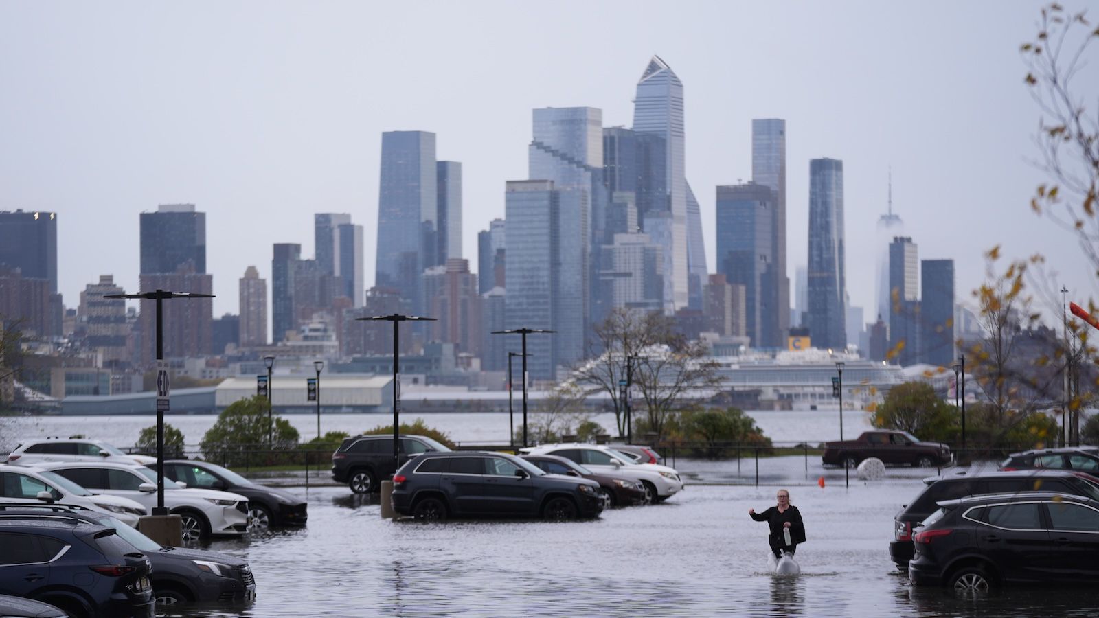
एक नए बाढ़ जोखिम सूचकांक ने मौजूदा परिदृश्यों के तहत अमेरिका के पूर्वी तट के आठ शहरों को अत्यधिक बाढ़ क्षति के उच्च या बहुत उच्च जोखिम में पाया है, और न्यूयॉर्क सिटी पूर्ण रूप से सबसे अधिक जोखिम में अलग दिखती है। Live Science द्वारा प्रमुखता से प्रस्तुत रिपोर्ट के अनुसार, विश्लेषण में शामिल पूर्वी तट के शहरों में न्यूयॉर्क में अत्यधिक बाढ़ क्षति के उच्च जोखिम में लोगों और इमारतों की संख्या सबसे अधिक थी।
मुख्य आंकड़ा चौंकाने वाला है: न्यूयॉर्क सिटी में 4.4 मिलियन लोग अत्यधिक क्षति के संपर्क में आ सकते हैं। इसका मतलब यह नहीं है कि उन सभी निवासियों पर समान परिणाम या समान समय-सीमा में असर पड़ेगा। इसका अर्थ यह है कि बाढ़ के संपर्क को बड़े पैमाने पर मापने पर यह शहर भौतिक और मानवीय संवेदनशीलता के एक बड़े केंद्र में स्थित है।
उसी रिपोर्ट में कहा गया है कि न्यू ऑरलियन्स भी सबसे अधिक खतरे वाले स्थानों में शामिल है, जिससे यह स्पष्ट होता है कि यह मुद्दा केवल एक ही महानगरीय क्षेत्र तक सीमित नहीं है। लेकिन न्यूयॉर्क की स्थिति महत्वपूर्ण है क्योंकि इसकी जनघनत्व, निर्मित परिवेश का विशाल मूल्य, और वित्त, परिवहन तथा आवास केंद्र के रूप में इसका राष्ट्रीय महत्व है। जब संयुक्त राज्य का सबसे अधिक आबादी वाला शहर तटीय बाढ़ सूचकांक में सबसे बड़े पूर्ण जोखिम वाले मामले के रूप में उभरता है, तो इसका महत्व स्थानीय नियोजन बहसों से कहीं आगे तक जाता है।
यह सूचकांक क्यों महत्वपूर्ण है
पूर्वी तट के शहरों के लिए बाढ़ कोई नया विषय नहीं है, लेकिन सूचकांक-आधारित आकलन इस खतरे को समझने के तरीके को बदल सकते हैं। केवल खतरे के नक्शों या अलग-अलग तूफानों के इतिहास पर ध्यान देने के बजाय, एक सूचकांक जोखिम के मापों को इस तरह जोड़ सकता है कि यह दिखे कि अत्यधिक क्षति की संभावना सबसे अधिक कहां सिमट रही है। इस मामले में, स्रोत पाठ दो प्रमुख आयामों पर जोर देता है: लोग और इमारतें।
यह दोहरा दृष्टिकोण महत्वपूर्ण है। किसी शहर में गंभीर बाढ़ खतरा हो सकता है, लेकिन यदि सबसे कमजोर क्षेत्रों में कम लोग या संरचनाएं हों, तो पूर्ण जोखिम सीमित रह सकता है। न्यूयॉर्क इसके उलट मामला है। इसका जोखिम संकेंद्रण से बढ़ जाता है। बड़ी आबादी, घना विकास, और बुनियादी ढांचे-प्रधान शहरी स्वरूप का मतलब है कि बाढ़ की क्षति आवास, परिवहन, उपयोगिताओं, वाणिज्य और आपातकालीन प्रतिक्रिया पर एक साथ प्रभाव डाल सकती है।
विश्लेषण एक व्यापक क्षेत्रीय पैटर्न की ओर भी संकेत करता है। पूर्वी तट के आठ शहरों को उच्च या बहुत उच्च जोखिम में वर्गीकृत किया गया। इससे पता चलता है कि समस्या अपवादात्मक नहीं बल्कि प्रणालीगत है। तटीय बाढ़ संवेदनशीलता सिर्फ एक ऐसे स्थान के बारे में नहीं है जहां तूफान बार-बार आते हैं। यह पूरे तटीय गलियारे की चुनौती है, जिसमें कई शहरी केंद्र गंभीर व्यवधान की आशंका का सामना कर रहे हैं।

सार्वभौमिक जलवायु जोखिम से शहरी क्षति की संभावना तक
इस तरह के अध्ययन ध्यान इसलिए आकर्षित करते हैं क्योंकि वे जलवायु और तटीय जोखिम को क्षति से जुड़े अधिक सीधे सवालों में बदल देते हैं। अत्यधिक बाढ़ क्षति केवल पानी की गहराई के बारे में नहीं है। यह इस बारे में है कि पानी के रास्ते में क्या है और किसी शहर की कितनी आबादी और निर्मित संरचना उस क्षेत्र में आ सकती है।
न्यूयॉर्क के लिए, यह चर्चा का स्वर बदल देता है। शहर ने पिछले तूफानी झटकों के बाद वर्षों से लचीलापन योजना बढ़ाने, बुनियादी ढांचे को मजबूत करने और जलतटीय विकास का पुनर्मूल्यांकन करने में समय लगाया है। फिर भी नया सूचकांक बताता है कि मौजूदा परिदृश्यों के तहत भी, जोखिम का पैमाना बेहद बड़ा बना हुआ है। दूसरे शब्दों में, यदि शहरी जोखिम का आधार स्तर इतना ऊंचा है, तो अनुकूलन प्रयास आवश्यक तो हो सकते हैं, लेकिन पर्याप्त नहीं।
यह निष्कर्ष नीति-निर्धारण की चुनौती को भी और स्पष्ट करता है। लाखों लोगों और विशाल भवन-भंडार की सुरक्षा, किसी छोटे और कम घने तटीय बस्ती की रक्षा से मूल रूप से अलग है। जो उपाय अलग-अलग जिलों में काम करते हैं, वे पूरे महानगरीय क्षेत्र में आसानी से लागू नहीं हो सकते। इसलिए न्यूयॉर्क की बाढ़ समस्या केवल बाधाएं बनाने या जल निकासी सुधारने का मामला नहीं है। यह प्राथमिकता-निर्धारण, भूमि उपयोग, बुनियादी ढांचे की परस्पर निर्भरता, और दीर्घकालिक निवेश क्षमता का भी सवाल है।
पूर्वी तट का पैटर्न क्या संकेत देता है
आठ उच्च-जोखिम या बहुत उच्च-जोखिम वाले पूर्वी तट शहरों को शामिल किए जाने से तटीय शहरी संवेदनशीलता पर चर्चा के तरीके में एक व्यापक बदलाव का संकेत मिलता है। बाढ़ जोखिम को अलग-अलग नगर-स्तरीय मुद्दों की श्रृंखला मानने के बजाय, यह सूचकांक इसे साझा संरचनात्मक कारकों वाले क्षेत्रीय पैटर्न के रूप में प्रस्तुत करता है। अटलांटिक तट पर स्थित शहर अक्सर पुराना बुनियादी ढांचा, केंद्रित संपत्तियां, और व्यापक तटीय संपर्क एक साथ समेटे होते हैं। इसका मतलब है कि जब सुरक्षा-प्रणालियां असफल होती हैं, तो क्षति तेजी से फैल सकती है।
न्यू ऑरलियन्स का रैंकिंग में शीर्ष के पास आना एक अलग शहरी संदर्भ से इसी बात को पुष्ट करता है। यह आकार या भूगोल में न्यूयॉर्क के समान नहीं है, लेकिन यह उसी व्यापक कहानी का हिस्सा है: कुछ अमेरिकी शहरों में बाढ़ जोखिम के ऐसे स्तर हैं जिन्हें सामान्य लचीलापन चुनौतियों के बजाय अत्यधिक-जोखिम प्रबंधन समस्याओं के रूप में समझना अधिक उचित है।
यह दृष्टिकोण आगे धन और राजनीतिक ध्यान के प्रवाह को प्रभावित कर सकता है। जोखिम रैंकिंग अक्सर सार्वजनिक बहस को आकार देती हैं क्योंकि वे शहरों की सीधी तुलना का तरीका देती हैं। एक बार किसी शहर की सबसे बड़ी पूर्ण जोखिम वाली जगह के रूप में पहचान हो जाए, तो प्रमाण प्रस्तुत करने का बोझ बदल जाता है। मुद्दा अब यह नहीं रह जाता कि बाढ़ जोखिम पर ध्यान देना चाहिए या नहीं। सवाल यह बन जाता है कि क्या मौजूदा योजना दस्तावेजी रूप से दर्ज खतरे के पैमाने से मेल खाती है।

राष्ट्रीय प्रभाव वाली चेतावनी
नया सूचकांक केवल स्थानीय खतरे को चिह्नित नहीं करता। यह दिखाता है कि राष्ट्रीय जोखिम का कितना बड़ा हिस्सा कुछ तटीय महानगरों में समाया हुआ है। न्यूयॉर्क में लोगों और इमारतों का संकेंद्रण यह दर्शाता है कि बाढ़ जोखिम आवास स्थिरता, आर्थिक निरंतरता, सार्वजनिक सेवाओं और आपातकालीन तैयारी के सवालों से अलग नहीं है। उस पैमाने की क्षति लंबे समय तक स्थानीय नहीं रहेगी।
इसीलिए रिपोर्ट का निष्कर्ष जलवायु विशेषज्ञों और शहर एजेंसियों से परे भी ध्यान पाने योग्य है। 4.4 मिलियन लोगों के अत्यधिक बाढ़ क्षति के जोखिम में होने वाला शहर किसी मामूली खतरे का सामना नहीं कर रहा है। वह एक बड़े शहरी जोखिम का सामना कर रहा है, जो बुनियादी ढांचे, बीमा, विकास और सार्वजनिक सुरक्षा सभी से एक साथ जुड़ता है। यदि सूचकांक सही है, तो न्यूयॉर्क केवल कई कमजोर शहरों में से एक नहीं है। यह इस बात का सबसे स्पष्ट उदाहरण है कि कैसे केंद्रित तटीय जोखिम बाढ़ को एक महानगरीय स्तर की प्रणालीगत समस्या में बदल सकता है।
यह लेख Live Science की रिपोर्टिंग पर आधारित है। मूल लेख पढ़ें.
Originally published on livescience.com